Blankenberge night lights from space
Night Light of Blankenberge (Flanders) from space (Belgium) Src. Average luminocity for 10x10km area is 39.9146% and for 50x50km: 16.1701%.
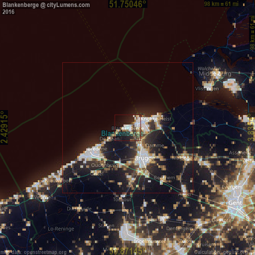
Analysis of Blankenberge night lights 2016
Square area 10x10 km:
 10.36%
90-99
7.14%80-89
1.82%70-79
3.78%60-69
5.6%50-59
6.44%40-49
3.64%30-39
6.44%20-29
10.78%10-19
25.77%0-9
18.21%Square area 50x50 km:
2.68%90-99
3.1%80-89
1.41%70-79
1.53%60-69
1.55%50-59
1.93%40-49
1.86%30-39
2.42%20-29
5.95%10-19
15.25%0-9
62.32%Clear (daylight) street map image can be seen on geolist.org.
Map coordinates:
51° 45' 1.7" North, 2° 25' 44.9" East
51° 18' 47" North, 3° 7' 56.2" East
50° 52' 17.2" North, 3° 50' 7.4" East
Some cities around Blankenberge sort by population:
• Brugge
13.2 km =8.2 mi,  151°
151°
• Knokke-Heist
10.2 km =6.3 mi,  66°
66°
• Sint-Kruis
13.7 km =8.5 mi,  143°
143°
• Bredene
13.9 km =8.6 mi,  231°
231°
• Jabbeke
14.9 km =9.3 mi,  191°
191°
• De Haan
8.2 km =5.1 mi,  236°
236°
• Damme
12.4 km =7.7 mi,  123°
123°
• Oudenburg
17 km =10.6 mi,  212°
212°
2801858 (p: 18,230)
Sources (retrieved 2019-11-25):
» Earth at Night: Flat Maps 2012, 2016