Vareš night lights from space
Night Light of Vareš (Federation of B&H) from space (Bosnia and Herzegovina) Src. Average luminocity for 10x10km area is 0% and for 50x50km: 1.4009%.
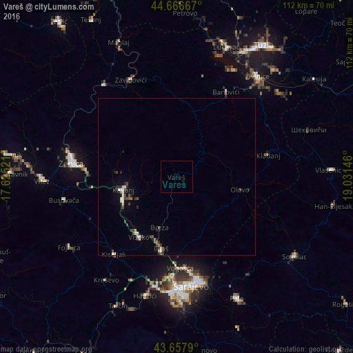
Analysis of Vareš night lights 2016
Square area 10x10 km:
 0%
0%90-99
0%80-89
0%70-79
0%60-69
0%50-59
0%40-49
0%30-39
0%20-29
0%10-19
0%0-9
100%Square area 50x50 km:
0.15%90-99
0.23%80-89
0.12%70-79
0.06%60-69
0.06%50-59
0.16%40-49
0.41%30-39
0.32%20-29
0.31%10-19
0.36%0-9
97.8%Clear (daylight) street map image can be seen on geolist.org.
Map coordinates:
44° 40' 0" North, 17° 37' 30.8" East
44° 9' 52" North, 18° 19' 42" East
43° 39' 28.4" North, 19° 1' 53.3" East
Some cities around Vareš sort by population:
• Visoko
22.9 km =14.2 mi,  211°
211°
• Kakanj
16.8 km =10.4 mi,  257°
257°
• Vogošća
29.2 km =18.1 mi,  177°
177°
• Kladanj
29.9 km =18.6 mi,  76°
76°
• Gromiljak
31 km =19.3 mi,  224°
224°
• Ilijaš
24.1 km =15 mi,  190°
190°
• Gostovići
30.2 km =18.8 mi,  335°
335°
• Mahala
17.9 km =11.1 mi,  198°
198°
3188366 (p: 7,193)
Sources (retrieved 2019-11-25):
» Earth at Night: Flat Maps 2012, 2016