Pottsville night lights from space
Night Light of Pottsville (New South Wales) from space (Australia) Src. Average luminocity for 10x10km area is 3.254% and for 50x50km: 2.6259%.
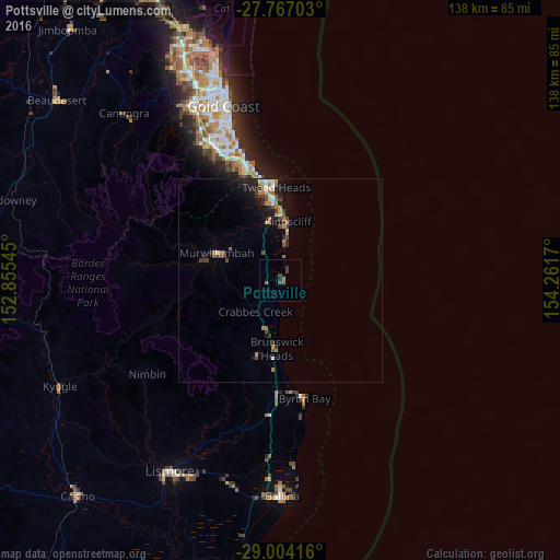
Analysis of Pottsville night lights 2016
Square area 10x10 km:
 0%
0%90-99
0%80-89
0%70-79
0%60-69
1.39%50-59
0.99%40-49
1.59%30-39
1.59%20-29
0.79%10-19
0%0-9
93.65%Square area 50x50 km:
0.23%90-99
0.23%80-89
0.16%70-79
0.11%60-69
0.85%50-59
0.4%40-49
0.46%30-39
0.55%20-29
0.56%10-19
2.26%0-9
94.19%Clear (daylight) street map image can be seen on geolist.org.
Map coordinates:
27° 46' 1.3" South, 152° 51' 19.6" East
28° 23' 14.6" South, 153° 33' 30.9" East
29° 0' 15" South, 154° 15' 42.1" East
Some cities around Pottsville sort by population:
• Banora Point
19.5 km =12.1 mi,  353°
353°
• Tweed Heads
23.5 km =14.6 mi,  356°
356°
• Coolangatta
24.3 km =15.1 mi, 354°
• Tweed Heads South
21.5 km =13.4 mi, 355°
• Kingscliff
14.3 km =8.9 mi,  7°
7°
• Murwillumbah
17.5 km =10.9 mi,  292°
292°
• Tweed Heads West
22.5 km =14 mi, 351°
• Ocean Shores
13.7 km =8.5 mi,  188°
188°
11704257 (p: 6,692)
Sources (retrieved 2019-11-25):
» Earth at Night: Flat Maps 2012, 2016