Kogarah night lights from space
Night Light of Kogarah (New South Wales) from space (Australia) Src. Average luminocity for 10x10km area is 77.1888% and for 50x50km: 41.8465%.
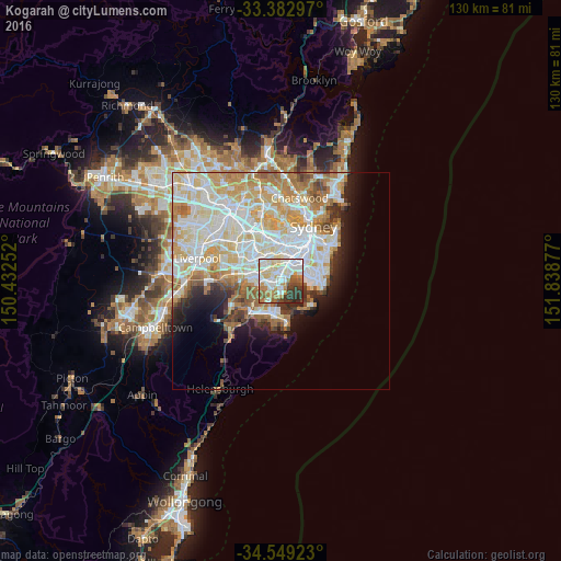
Analysis of Kogarah night lights 2016
Square area 10x10 km:
 21.85%
90-99
22.73%80-89
11.71%70-79
10.14%60-69
10.31%50-59
5.94%40-49
4.02%30-39
9.79%20-29
3.5%10-19
0%0-9
0%Square area 50x50 km:
11.15%90-99
11.94%80-89
5.97%70-79
6.38%60-69
6.06%50-59
3.03%40-49
1.97%30-39
2.46%20-29
3.34%10-19
5.71%0-9
41.99%Clear (daylight) street map image can be seen on geolist.org.
Map coordinates:
33° 22' 58.7" South, 150° 25' 57.1" East
33° 58' 5.2" South, 151° 8' 8.3" East
34° 32' 57.2" South, 151° 50' 19.6" East
Some cities around Kogarah sort by population:
• Hurstville
3.1 km =1.9 mi,  270°
270°
• Bexley
2.7 km =1.7 mi,  318°
318°
• Rockdale
2 km =1.2 mi,  353°
353°
• Carlton
1.4 km =0.9 mi,  255°
255°
• Sans Souci
2.4 km =1.5 mi,  185°
185°
• Brighton-Le-Sands
1.7 km =1.1 mi,  58°
58°
• Allawah
2 km =1.2 mi, 255°
• South Hurstville
3 km =1.9 mi,  249°
249°
2161185 (p: 15,705)
Sources (retrieved 2019-11-25):
» Earth at Night: Flat Maps 2012, 2016