Brighton-Le-Sands night lights from space
Night Light of Brighton-Le-Sands (New South Wales) from space (Australia) Src. Average luminocity for 10x10km area is 80.1783% and for 50x50km: 41.2131%.
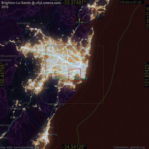
Analysis of Brighton-Le-Sands night lights 2016
Square area 10x10 km:
 28.85%
90-99
24.13%80-89
10.31%70-79
8.92%60-69
7.34%50-59
4.37%40-49
3.32%30-39
10.14%20-29
2.62%10-19
0%0-9
0%Square area 50x50 km:
10.95%90-99
11.72%80-89
5.98%70-79
6.08%60-69
6%50-59
3.13%40-49
2.04%30-39
2.52%20-29
3.18%10-19
5.56%0-9
42.83%Clear (daylight) street map image can be seen on geolist.org.
Map coordinates:
33° 22' 29.7" South, 150° 26' 52.7" East
33° 57' 36.3" South, 151° 9' 4" East
34° 32' 28.6" South, 151° 51' 15.2" East
Some cities around Brighton-Le-Sands sort by population:
• Bexley
3.4 km =2.1 mi,  289°
289°
• Kogarah
1.7 km =1.1 mi,  238°
238°
• Rockdale
2 km =1.2 mi,  304°
304°
• Carlton
3 km =1.9 mi,  246°
246°
• Arncliffe
2.7 km =1.7 mi,  354°
354°
• Sans Souci
3.7 km =2.3 mi,  206°
206°
• Wolli Creek
3.2 km =2 mi,  1°
1°
• Allawah
3.7 km =2.3 mi, 247°
2205999 (p: 8,515)
Sources (retrieved 2019-11-25):
» Earth at Night: Flat Maps 2012, 2016