Goonellabah night lights from space
Night Light of Goonellabah (New South Wales) from space (Australia) Src. Average luminocity for 10x10km area is 15.5777% and for 50x50km: 1.8498%.
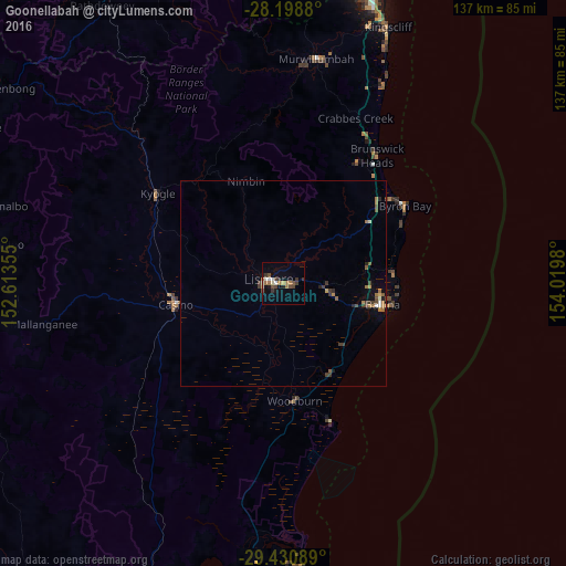
Analysis of Goonellabah night lights 2016
Square area 10x10 km:
 1.7%
1.7%90-99
1.7%80-89
1.14%70-79
0.76%60-69
4.92%50-59
0.76%40-49
4.17%30-39
4.36%20-29
0.76%10-19
3.6%0-9
76.14%Square area 50x50 km:
0.14%90-99
0.13%80-89
0.11%70-79
0.14%60-69
0.6%50-59
0.23%40-49
0.4%30-39
0.57%20-29
0.21%10-19
0.34%0-9
97.13%Clear (daylight) street map image can be seen on geolist.org.
Map coordinates:
28° 11' 55.7" South, 152° 36' 48.8" East
28° 49' 0" South, 153° 19' 0" East
29° 25' 51.2" South, 154° 1' 11.3" East
Some cities around Goonellabah sort by population:
• Casino
26.6 km =16.5 mi,  260°
260°
• Ballina
24.8 km =15.4 mi,  102°
102°
• Byron Bay
34.3 km =21.3 mi,  57°
57°
• Lennox Head
27 km =16.8 mi,  83°
83°
• Alstonville
12.4 km =7.7 mi, 103°
• East Ballina
26.7 km =16.6 mi, 99°
• Ocean Shores
40.4 km =25.1 mi,  32°
32°
• East Lismore
2.9 km =1.8 mi,  249°
249°
2164966 (p: 12,781)
Sources (retrieved 2019-11-25):
» Earth at Night: Flat Maps 2012, 2016