Cooranbong night lights from space
Night Light of Cooranbong (New South Wales) from space (Australia) Src. Average luminocity for 10x10km area is 8.174% and for 50x50km: 9.7562%.
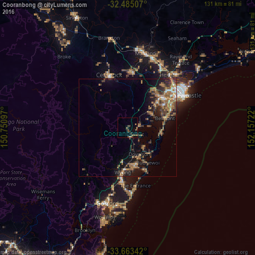
Analysis of Cooranbong night lights 2016
Square area 10x10 km:
 0%
0%90-99
0.37%80-89
0.37%70-79
1.47%60-69
0.92%50-59
2.01%40-49
3.66%30-39
1.47%20-29
2.2%10-19
1.28%0-9
86.26%Square area 50x50 km:
0.47%90-99
0.61%80-89
0.47%70-79
1.83%60-69
3.12%50-59
1.84%40-49
1.7%30-39
2.37%20-29
2.29%10-19
6.25%0-9
79.04%Clear (daylight) street map image can be seen on geolist.org.
Map coordinates:
32° 29' 6.3" South, 150° 45' 3.5" East
33° 4' 34.4" South, 151° 27' 14.7" East
33° 39' 48.3" South, 152° 9' 26" East
Some cities around Cooranbong sort by population:
• Belmont
20 km =12.4 mi,  74°
74°
• Blue Haven
15.7 km =9.8 mi,  162°
162°
• Hamlyn Terrace
19.6 km =12.2 mi,  173°
173°
• Toronto
14.8 km =9.2 mi,  61°
61°
• Eleebana
19.5 km =12.1 mi, 60°
• Valentine
18.9 km =11.7 mi, 68°
• Woongarrah
18.5 km =11.5 mi, 173°
• Lake Munmorah
18 km =11.2 mi,  138°
138°
2170456 (p: 5,377)
Sources (retrieved 2019-11-25):
» Earth at Night: Flat Maps 2012, 2016