Bangor night lights from space
Night Light of Bangor (New South Wales) from space (Australia) Src. Average luminocity for 10x10km area is 51.3304% and for 50x50km: 42.3031%.
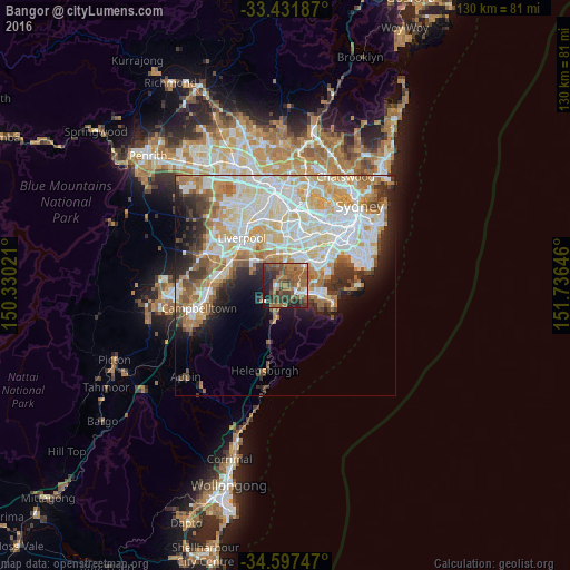
Analysis of Bangor night lights 2016
Square area 10x10 km:
 3.5%
3.5%90-99
4.2%80-89
1.4%70-79
4.9%60-69
21.68%50-59
19.58%40-49
13.11%30-39
12.59%20-29
12.76%10-19
6.12%0-9
0.17%Square area 50x50 km:
11.18%90-99
11.25%80-89
5.46%70-79
5.78%60-69
5.93%50-59
4%40-49
2.98%30-39
4.15%20-29
4.79%10-19
6.59%0-9
37.9%Clear (daylight) street map image can be seen on geolist.org.
Map coordinates:
33° 25' 54.7" South, 150° 19' 48.8" East
34° 1' 0" South, 151° 1' 60" East
34° 35' 50.9" South, 151° 44' 11.3" East
Some cities around Bangor sort by population:
• Sutherland
2.6 km =1.6 mi,  128°
128°
• Menai
1.5 km =0.9 mi,  270°
270°
• Kirrawee
4.1 km =2.5 mi, 126°
• Illawong
1.9 km =1.2 mi,  0°
0°
• Jannali
2.5 km =1.6 mi,  89°
89°
• Picnic Point
5.2 km =3.2 mi,  319°
319°
• Lugarno
3.9 km =2.4 mi,  11°
11°
• Oyster Bay
4.2 km =2.6 mi,  70°
70°
2205982 (p: 5,471)
Sources (retrieved 2019-11-25):
» Earth at Night: Flat Maps 2012, 2016