Sankt Valentin night lights from space
Night Light of Sankt Valentin (Lower Austria) from space (Austria) Src. Average luminocity for 10x10km area is 9.3824% and for 50x50km: 7.3037%.
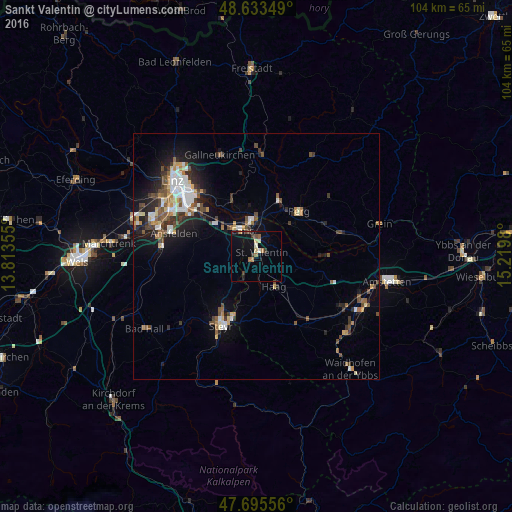
Analysis of Sankt Valentin night lights 2016
Square area 10x10 km:
 0.45%
0.45%90-99
0.74%80-89
2.08%70-79
0.45%60-69
1.64%50-59
0.89%40-49
1.19%30-39
2.38%20-29
0.3%10-19
5.95%0-9
83.93%Square area 50x50 km:
1.01%90-99
1.25%80-89
0.7%70-79
0.69%60-69
0.81%50-59
1.01%40-49
1.34%30-39
1.23%20-29
1.69%10-19
4.29%0-9
85.98%Clear (daylight) street map image can be seen on geolist.org.
Map coordinates:
48° 38' 0.6" North, 13° 48' 48.8" East
48° 10' 0" North, 14° 31' 0" East
47° 41' 44" North, 15° 13' 11.3" East
Some cities around Sankt Valentin sort by population:
• Steyr
15.5 km =9.6 mi,  207°
207°
• Traun
21.5 km =13.4 mi,  286°
286°
• Enns
6 km =3.7 mi,  329°
329°
• Haid
20.1 km =12.5 mi,  282°
282°
• Neuhofen an der Krems
21.7 km =13.5 mi,  261°
261°
• Perg
12.7 km =7.9 mi,  43°
43°
• Neuzeug
18.8 km =11.7 mi,  226°
226°
• Haag
21.7 km =13.5 mi,  302°
302°
2766365 (p: 9,340)
Sources (retrieved 2019-11-25):
» Earth at Night: Flat Maps 2012, 2016