Neunkirchen night lights from space
Night Light of Neunkirchen (Lower Austria) from space (Austria) Src. Average luminocity for 10x10km area is 16.8051% and for 50x50km: 5.7442%.
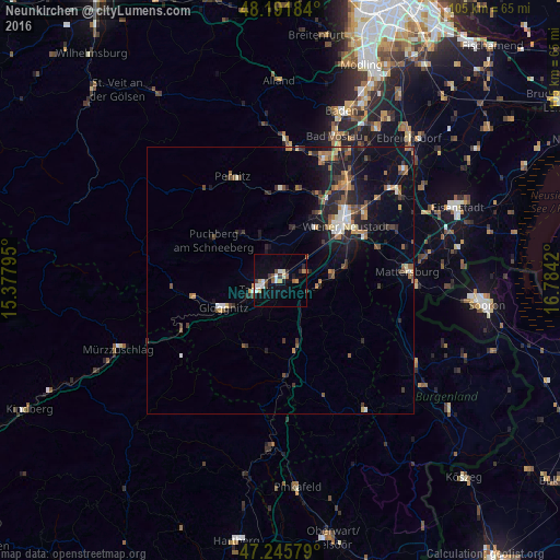
Analysis of Neunkirchen night lights 2016
Square area 10x10 km:
 1.79%
1.79%90-99
3.87%80-89
1.19%70-79
2.53%60-69
1.49%50-59
1.49%40-49
1.79%30-39
2.53%20-29
2.08%10-19
5.65%0-9
75.6%Square area 50x50 km:
0.46%90-99
0.73%80-89
0.37%70-79
0.81%60-69
0.84%50-59
0.92%40-49
0.82%30-39
1.06%20-29
1.62%10-19
4.3%0-9
88.06%Clear (daylight) street map image can be seen on geolist.org.
Map coordinates:
48° 11' 30.6" North, 15° 22' 40.6" East
47° 43' 15.5" North, 16° 4' 51.9" East
47° 14' 44.8" North, 16° 47' 3.1" East
Some cities around Neunkirchen sort by population:
• Wiener Neustadt
14.6 km =9.1 mi,  50°
50°
• Berndorf
25.1 km =15.6 mi,  4°
4°
• Bad Vöslau
28.9 km =18 mi,  19°
19°
• Kottingbrunn
27.8 km =17.3 mi, 23°
• Ternitz
3.4 km =2.1 mi,  260°
260°
• Mattersburg
23.9 km =14.9 mi,  86°
86°
• Mürzzuschlag
33.1 km =20.6 mi,  247°
247°
• Sollenau
23.3 km =14.5 mi,  32°
32°
2770711 (p: 11,461)
Sources (retrieved 2019-11-25):
» Earth at Night: Flat Maps 2012, 2016