Villa Elisa night lights from space
Night Light of Villa Elisa (Entre Rios) from space (Argentina) Src. Average luminocity for 10x10km area is 11.6294% and for 50x50km: 3.5595%.
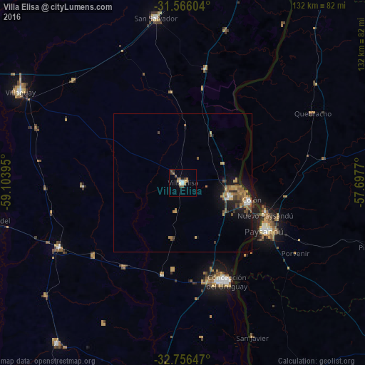
Analysis of Villa Elisa night lights 2016
Square area 10x10 km:
 1.57%
1.57%90-99
0.7%80-89
1.05%70-79
2.27%60-69
2.1%50-59
3.5%40-49
1.22%30-39
0.17%20-29
1.05%10-19
0.35%0-9
86.01%Square area 50x50 km:
0.26%90-99
0.28%80-89
0.38%70-79
0.75%60-69
0.61%50-59
1%40-49
0.32%30-39
0.46%20-29
0.57%10-19
2.61%0-9
92.75%Clear (daylight) street map image can be seen on geolist.org.
Map coordinates:
31° 33' 57.7" South, 59° 6' 14.2" West
32° 9' 47.5" South, 58° 24' 3" West
32° 45' 23.3" South, 57° 41' 51.7" West
Some cities around Villa Elisa sort by population:
• Concordia
92.9 km =57.7 mi,  22°
22°
• Paysandú, UY
34.6 km =21.5 mi,  119°
119°
• Concepción del Uruguay
39.1 km =24.3 mi,  156°
156°
• Young, UY
93.9 km =58.3 mi,  129°
129°
• Rosario del Tala
71.7 km =44.6 mi,  257°
257°
• San Salvador
60.7 km =37.7 mi,  350°
350°
• Urdinarrain
74.2 km =46.1 mi,  218°
218°
• Maciá
94 km =58.4 mi,  269°
269°
3427443 (p: 9,334)
Sources (retrieved 2019-11-25):
» Earth at Night: Flat Maps 2012, 2016