General Fernández Oro night lights from space
Night Light of General Fernández Oro (Rio Negro) from space (Argentina) Src. Average luminocity for 10x10km area is 40.4643% and for 50x50km: 13.9143%.
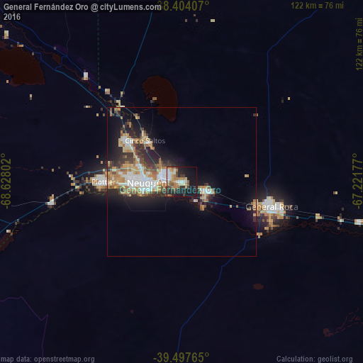
Analysis of General Fernández Oro night lights 2016
Square area 10x10 km:
 5.19%
5.19%90-99
7.31%80-89
3.08%70-79
6.98%60-69
10.23%50-59
3.25%40-49
5.36%30-39
6.66%20-29
9.74%10-19
33.28%0-9
8.93%Square area 50x50 km:
2.02%90-99
2.29%80-89
1.48%70-79
1.86%60-69
3.4%50-59
0.94%40-49
1.8%30-39
2.07%20-29
4.14%10-19
8.37%0-9
71.65%Clear (daylight) street map image can be seen on geolist.org.
Map coordinates:
38° 24' 14.7" South, 68° 37' 40.9" West
38° 57' 10.7" South, 67° 55' 29.6" West
39° 29' 51.5" South, 67° 13' 18.4" West
Some cities around General Fernández Oro sort by population:
• Neuquén
11.6 km =7.2 mi,  270°
270°
• Cipolletti
6 km =3.7 mi,  290°
290°
• Centenario
22.6 km =14 mi,  307°
307°
• Allen
8.9 km =5.5 mi,  107°
107°
• Plottier
26.7 km =16.6 mi, 266°
• Cinco Saltos
18.8 km =11.7 mi,  320°
320°
• Senillosa
44.4 km =27.6 mi,  261°
261°
• Cervantes
47.2 km =29.3 mi,  103°
103°
3855114 (p: 6,813)
Sources (retrieved 2019-11-25):
» Earth at Night: Flat Maps 2012, 2016