Fray Luis A. Beltrán night lights from space
Night Light of Fray Luis A. Beltrán (Santa Fe) from space (Argentina) Src. Average luminocity for 10x10km area is 52.5682% and for 50x50km: 22.1518%.
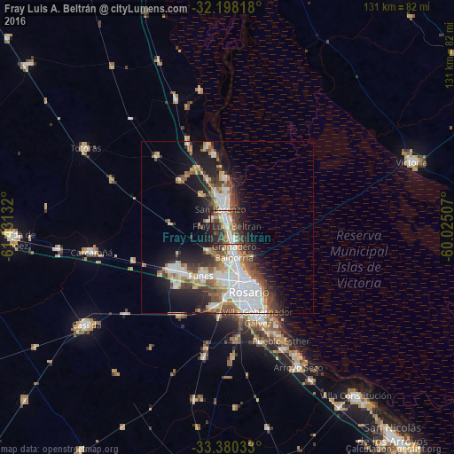
Analysis of Fray Luis A. Beltrán night lights 2016
Square area 10x10 km:
 7.69%
7.69%90-99
12.41%80-89
3.5%70-79
8.57%60-69
6.29%50-59
4.9%40-49
11.54%30-39
13.99%20-29
21.85%10-19
9.27%0-9
0%Square area 50x50 km:
5.35%90-99
4.56%80-89
1.88%70-79
2.31%60-69
2.67%50-59
2.57%40-49
3.16%30-39
3.25%20-29
5.07%10-19
10.42%0-9
58.75%Clear (daylight) street map image can be seen on geolist.org.
Map coordinates:
32° 11' 53.4" South, 61° 25' 52.8" West
32° 47' 28.4" South, 60° 43' 41.5" West
33° 22' 49.2" South, 60° 1' 30.3" West
Some cities around Fray Luis A. Beltrán sort by population:
• Rosario
19.2 km =11.9 mi,  154°
154°
• Gobernador Gálvez
27.8 km =17.3 mi,  162°
162°
• Granadero Baigorria
7.4 km =4.6 mi,  172°
172°
• Capitán Bermúdez
3.6 km =2.2 mi, 165°
• Pérez
23.3 km =14.5 mi,  189°
189°
• Carcarañá
40.4 km =25.1 mi,  259°
259°
• Funes
15.8 km =9.8 mi,  208°
208°
• Roldán
20.5 km =12.7 mi,  234°
234°
3855370 (p: 14,390)
Sources (retrieved 2019-11-25):
» Earth at Night: Flat Maps 2012, 2016