Wind Lake night lights from space
Night Light of Wind Lake (Wisconsin) from space (United States) Src. Average luminocity for 10x10km area is 9.4697% and for 50x50km: 32.2792%.
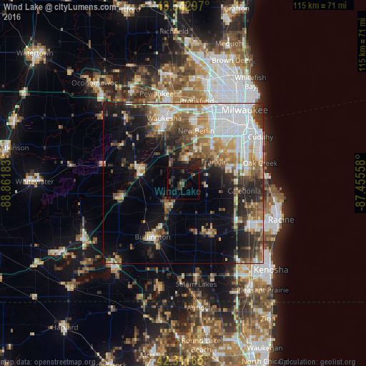
Analysis of Wind Lake night lights 2016
Square area 10x10 km:
 0%
0%90-99
0%80-89
0%70-79
0%60-69
0.61%50-59
0.91%40-49
1.52%30-39
5.15%20-29
5.15%10-19
13.03%0-9
73.64%Square area 50x50 km:
8.87%90-99
4.77%80-89
3.15%70-79
3.44%60-69
4.72%50-59
4.44%40-49
4.22%30-39
4.07%20-29
7.43%10-19
10.8%0-9
44.09%Clear (daylight) street map image can be seen on geolist.org.
Map coordinates:
43° 20' 34.7" North, 88° 51' 42.6" West
42° 49' 46.1" North, 88° 9' 31.3" West
42° 18' 41.9" North, 87° 27' 20.1" West
Some cities around Wind Lake sort by population:
• New Berlin
16.8 km =10.4 mi,  14°
14°
• Franklin
11.8 km =7.3 mi,  56°
56°
• Muskego
8.6 km =5.3 mi, 10°
• Greendale
18.1 km =11.2 mi,  47°
47°
• Hales Corners
15 km =9.3 mi,  36°
36°
• Mukwonago
14.8 km =9.2 mi,  286°
286°
• Waterford
8.7 km =5.4 mi,  211°
211°
• Tichigan
3.2 km =2 mi,  268°
268°
5279285 (p: 5,342)
Sources (retrieved 2019-11-25):
» Earth at Night: Flat Maps 2012, 2016