Walterboro night lights from space
Night Light of Walterboro (South Carolina) from space (United States) Src. Average luminocity for 10x10km area is 51.2436% and for 50x50km: 4.861%.
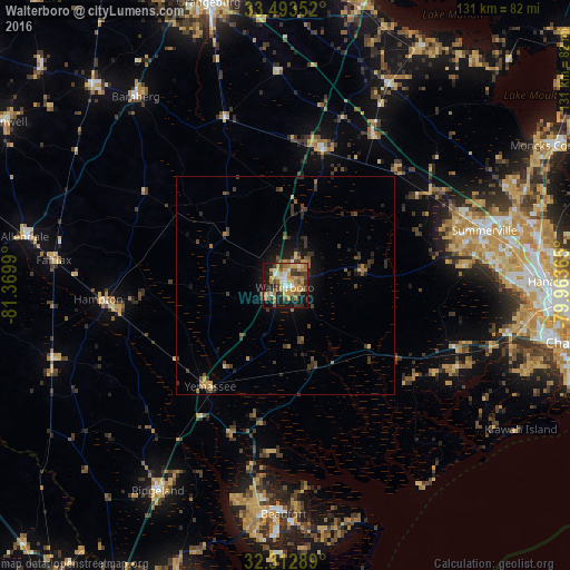
Analysis of Walterboro night lights 2016
Square area 10x10 km:
 4.03%
4.03%90-99
7.33%80-89
8.61%70-79
13.55%60-69
14.29%50-59
3.66%40-49
8.61%30-39
6.23%20-29
9.71%10-19
22.89%0-9
1.1%Square area 50x50 km:
0.18%90-99
0.31%80-89
0.61%70-79
0.76%60-69
1.01%50-59
0.61%40-49
1.01%30-39
1.49%20-29
1.28%10-19
3.28%0-9
89.47%Clear (daylight) street map image can be seen on geolist.org.
Map coordinates:
33° 29' 36.7" North, 81° 22' 11.6" West
32° 54' 18.6" North, 80° 40' 0.4" West
32° 18' 46.4" North, 79° 57' 49.1" West
Some cities around Walterboro sort by population:
• Summerville
47.5 km =29.5 mi,  74°
74°
• Ladson
52.7 km =32.7 mi,  80°
80°
• Beaufort
52.7 km =32.7 mi,  180°
180°
• Port Royal
58.5 km =36.4 mi, 182°
• Sangaree
52.3 km =32.5 mi, 73°
• Burton
52.5 km =32.6 mi,  185°
185°
• Laurel Bay
51.8 km =32.2 mi, 192°
• Centerville
47.4 km =29.5 mi, 77°
4600065 (p: 5,278)
Sources (retrieved 2019-11-25):
» Earth at Night: Flat Maps 2012, 2016