Springfield night lights from space
Night Light of Springfield (Tennessee) from space (United States) Src. Average luminocity for 10x10km area is 46.0476% and for 50x50km: 16.2592%.
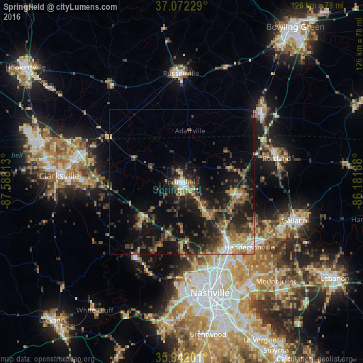
Analysis of Springfield night lights 2016
Square area 10x10 km:
 6.78%
6.78%90-99
6.41%80-89
8.97%70-79
5.68%60-69
7.33%50-59
6.96%40-49
4.03%30-39
10.99%20-29
12.45%10-19
26.74%0-9
3.66%Square area 50x50 km:
1.22%90-99
1.26%80-89
2.05%70-79
1.81%60-69
2.62%50-59
2.88%40-49
2.97%30-39
5.26%20-29
5.74%10-19
13.93%0-9
60.25%Clear (daylight) street map image can be seen on geolist.org.
Map coordinates:
37° 4' 20.2" North, 87° 35' 17.3" West
36° 30' 33.2" North, 86° 53' 6" West
35° 56' 31.2" North, 86° 10' 54.8" West
Some cities around Springfield sort by population:
• Hendersonville
32.8 km =20.4 mi,  133°
133°
• Goodlettsville
25.8 km =16 mi,  143°
143°
• Portland
33.9 km =21.1 mi,  76°
76°
• White House
21.3 km =13.2 mi,  101°
101°
• Franklin
36.3 km =22.6 mi,  49°
49°
• Russellville
37.4 km =23.2 mi,  359°
359°
• Greenbrier
11.6 km =7.2 mi, 141°
• Millersville
21.9 km =13.6 mi, 134°
4659557 (p: 16,808)
Sources (retrieved 2019-11-25):
» Earth at Night: Flat Maps 2012, 2016