Darby night lights from space
Night Light of Darby (Pennsylvania) from space (United States) Src. Average luminocity for 10x10km area is 98.2398% and for 50x50km: 78.5246%.
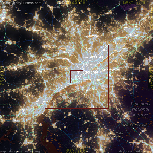
Analysis of Darby night lights 2016
Square area 10x10 km:
 70.41%
90-99
21.94%80-89
5.95%70-79
1.7%60-69
0%50-59
0%40-49
0%30-39
0%20-29
0%10-19
0%0-9
0%Square area 50x50 km:
25.41%90-99
18.24%80-89
10.59%70-79
12.94%60-69
12.37%50-59
8.26%40-49
5.54%30-39
3.5%20-29
1.63%10-19
1.48%0-9
0.04%Clear (daylight) street map image can be seen on geolist.org.
Map coordinates:
40° 27' 20.1" North, 75° 57' 43.9" West
39° 55' 6.4" North, 75° 15' 32.7" West
39° 22' 37.4" North, 74° 33' 21.4" West
Some cities around Darby sort by population:
• Drexel Hill
4.3 km =2.7 mi,  318°
318°
• Yeadon
2.3 km =1.4 mi,  7°
7°
• Lansdowne
2.4 km =1.5 mi,  333°
333°
• Collingdale
1.7 km =1.1 mi,  244°
244°
• Glenolden
3.3 km =2.1 mi,  231°
231°
• Clifton Heights
3.4 km =2.1 mi,  290°
290°
• Folcroft
3.7 km =2.3 mi,  214°
214°
• Sharon Hill
1.7 km =1.1 mi,  218°
218°
4557485 (p: 10,687)
Sources (retrieved 2019-11-25):
» Earth at Night: Flat Maps 2012, 2016