Brier night lights from space
Night Light of Brier (Washington) from space (United States) Src. Average luminocity for 10x10km area is 77.3542% and for 50x50km: 34.5911%.
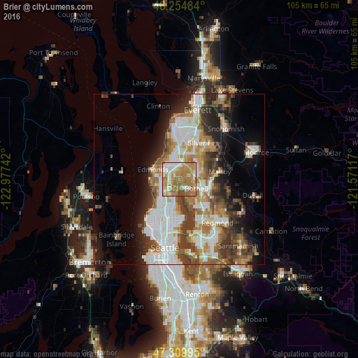
Analysis of Brier night lights 2016
Square area 10x10 km:
 13.99%
90-99
17.56%80-89
6.85%70-79
21.28%60-69
32.14%50-59
5.95%40-49
2.23%30-39
0%20-29
0%10-19
0%0-9
0%Square area 50x50 km:
8.72%90-99
7.66%80-89
2.59%70-79
4.59%60-69
5.67%50-59
3.86%40-49
4.44%30-39
5.25%20-29
5.71%10-19
8.02%0-9
43.5%Clear (daylight) street map image can be seen on geolist.org.
Map coordinates:
48° 15' 17.4" North, 122° 58' 38.7" West
47° 47' 4.3" North, 122° 16' 27.4" West
47° 18' 35.8" North, 121° 34' 16.2" West
Some cities around Brier sort by population:
• Shoreline
6 km =3.7 mi,  237°
237°
• Bothell
5.7 km =3.5 mi,  115°
115°
• Lynnwood
5.1 km =3.2 mi,  322°
322°
• Kenmore
3.8 km =2.4 mi,  143°
143°
• Mountlake Terrace
2.6 km =1.6 mi,  278°
278°
• Bothell West
3.4 km =2.1 mi,  47°
47°
• Lake Forest Park
3.1 km =1.9 mi,  189°
189°
• Alderwood Manor
4.2 km =2.6 mi,  352°
352°
5788125 (p: 6,656)
Sources (retrieved 2019-11-25):
» Earth at Night: Flat Maps 2012, 2016