Asbury Lake night lights from space
Night Light of Asbury Lake (Florida) from space (United States) Src. Average luminocity for 10x10km area is 30.0133% and for 50x50km: 24.9202%.
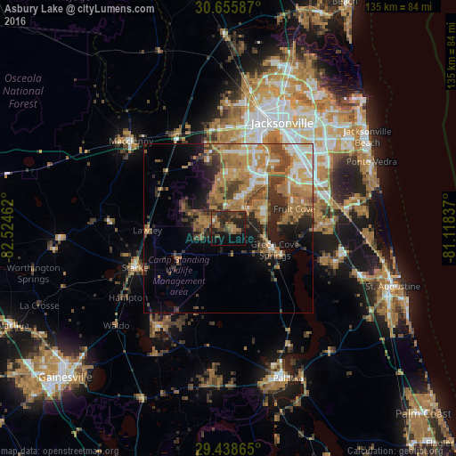
Analysis of Asbury Lake night lights 2016
Square area 10x10 km:
 0%
0%90-99
0.76%80-89
0%70-79
3.03%60-69
12.12%50-59
4.36%40-49
10.98%30-39
10.42%20-29
20.64%10-19
17.8%0-9
19.89%Square area 50x50 km:
2.62%90-99
2.99%80-89
1.71%70-79
6.09%60-69
7.87%50-59
3.14%40-49
4.61%30-39
4.31%20-29
5.22%10-19
7.37%0-9
54.07%Clear (daylight) street map image can be seen on geolist.org.
Map coordinates:
30° 39' 21.1" North, 82° 31' 28.6" West
30° 2' 56.9" North, 81° 49' 17.4" West
29° 26' 19.1" North, 81° 7' 6.1" West
Some cities around Asbury Lake sort by population:
• Lakeside
10.3 km =6.4 mi,  29°
29°
• Fruit Cove
18.6 km =11.6 mi,  68°
68°
• Fleming Island
11 km =6.8 mi,  63°
63°
• Oakleaf Plantation
13.6 km =8.5 mi,  354°
354°
• Bellair-Meadowbrook Terrace
16.3 km =10.1 mi, 27°
• Middleburg
4.3 km =2.7 mi,  300°
300°
• Orange Park
17.1 km =10.6 mi,  40°
40°
• Green Cove Springs
15.2 km =9.4 mi,  114°
114°
4146302 (p: 8,700)
Sources (retrieved 2019-11-25):
» Earth at Night: Flat Maps 2012, 2016