Apollo Beach night lights from space
Night Light of Apollo Beach (Florida) from space (United States) Src. Average luminocity for 10x10km area is 61.8353% and for 50x50km: 43.886%.
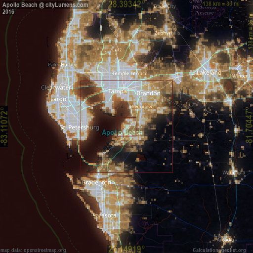
Analysis of Apollo Beach night lights 2016
Square area 10x10 km:
 6.35%
6.35%90-99
13.89%80-89
7.94%70-79
6.94%60-69
22.42%50-59
16.67%40-49
3.57%30-39
2.78%20-29
11.9%10-19
7.54%0-9
0%Square area 50x50 km:
10.72%90-99
7.8%80-89
4.35%70-79
4.5%60-69
10.85%50-59
6.06%40-49
4.54%30-39
5.18%20-29
8.98%10-19
11.67%0-9
25.34%Clear (daylight) street map image can be seen on geolist.org.
Map coordinates:
28° 23' 36.3" North, 83° 6' 38.6" West
27° 46' 23.1" North, 82° 24' 27.3" West
27° 8' 57.1" North, 81° 42' 16.1" West
Some cities around Apollo Beach sort by population:
• Riverview
13.1 km =8.1 mi,  37°
37°
• Palm River-Clair Mel
17 km =10.6 mi,  9°
9°
• Sun City Center
8.2 km =5.1 mi,  138°
138°
• Ruskin
6.3 km =3.9 mi,  203°
203°
• Gibsonton
9.3 km =5.8 mi,  15°
15°
• Boyette
18.9 km =11.7 mi,  74°
74°
• Wimauma
12.6 km =7.8 mi,  122°
122°
• Progress Village
14.8 km =9.2 mi, 16°
4146161 (p: 14,055)
Sources (retrieved 2019-11-25):
» Earth at Night: Flat Maps 2012, 2016