Iza night lights from space
Night Light of Iza (Transcarpathia) from space (Ukraine) Src. Average luminocity for 10x10km area is 3.5699% and for 50x50km: 0.4196%.
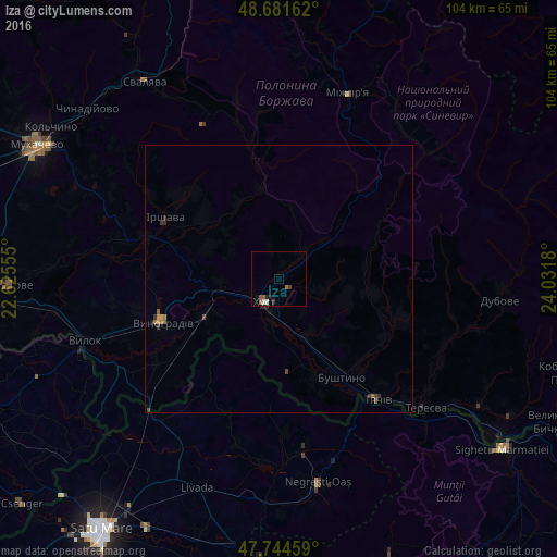
Analysis of Iza night lights 2016
Square area 10x10 km:
 0.45%
0.45%90-99
0.74%80-89
0%70-79
0%60-69
1.19%50-59
1.19%40-49
0%30-39
0.6%20-29
0.89%10-19
1.79%0-9
93.15%Square area 50x50 km:
0.02%90-99
0.03%80-89
0.02%70-79
0.05%60-69
0.12%50-59
0.14%40-49
0.07%30-39
0.13%20-29
0.14%10-19
0.1%0-9
99.19%Clear (daylight) street map image can be seen on geolist.org.
Map coordinates:
48° 40' 53.8" North, 22° 37' 32" East
48° 12' 54.9" North, 23° 19' 43.2" East
47° 44' 40.5" North, 24° 1' 54.5" East
Some cities around Iza sort by population:
• Khust
4.6 km =2.9 mi,  208°
208°
• Vynohradiv
23.9 km =14.9 mi,  249°
249°
• Irshava
24.3 km =15.1 mi,  297°
297°
• Bushtyno
21.6 km =13.4 mi,  147°
147°
• Korolevo
15.9 km =9.9 mi,  243°
243°
• Vyshkovo
19.7 km =12.2 mi,  159°
159°
• Bilky
18.3 km =11.4 mi,  307°
307°
• Dovhe
17.1 km =10.6 mi,  347°
347°
707317 (p: 5,237)
Sources (retrieved 2019-11-25):
» Earth at Night: Flat Maps 2012, 2016