Sarıyahşi night lights from space
Night Light of Sarıyahşi (Aksaray) from space (Turkey) Src. Average luminocity for 10x10km area is 8.5958% and for 50x50km: 2.5125%.
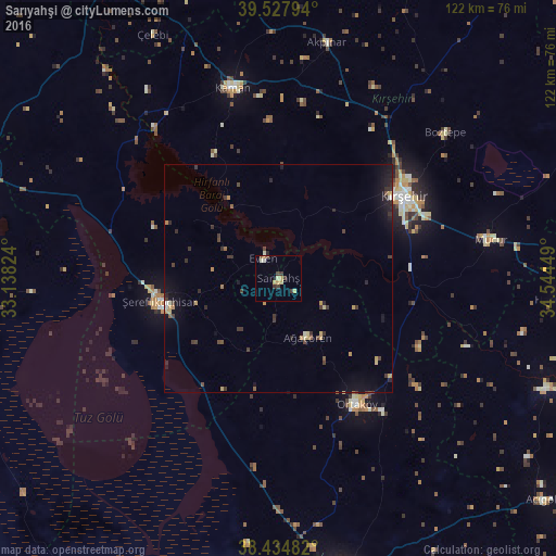
Analysis of Sarıyahşi night lights 2016
Square area 10x10 km:
 0%
0%90-99
1.3%80-89
2.6%70-79
1.46%60-69
0.49%50-59
0.65%40-49
1.14%30-39
3.41%20-29
0%10-19
0.65%0-9
88.31%Square area 50x50 km:
0.06%90-99
0.19%80-89
0.36%70-79
0.44%60-69
0.15%50-59
0.26%40-49
0.42%30-39
0.89%20-29
0.62%10-19
1.7%0-9
94.91%Clear (daylight) street map image can be seen on geolist.org.
Map coordinates:
39° 31' 40.6" North, 33° 8' 17.7" East
38° 59' 0.6" North, 33° 50' 28.9" East
38° 26' 5.4" North, 34° 32' 40.2" East
Some cities around Sarıyahşi sort by population:
• Kırşehir
33.2 km =20.6 mi,  57°
57°
• Kulu
66.9 km =41.6 mi,  280°
280°
• Şereflikoçhisar
26.6 km =16.5 mi,  259°
259°
• Ortaköy
32.3 km =20.1 mi,  148°
148°
• Kaman
42.8 km =26.6 mi,  346°
346°
• Mucur
47.6 km =29.6 mi,  79°
79°
• Hacıbektaş
62.1 km =38.6 mi,  94°
94°
• Ağaçören
13.7 km =8.5 mi, 151°
301566 (p: 8,704)
Sources (retrieved 2019-11-25):
» Earth at Night: Flat Maps 2012, 2016