Kindirip night lights from space
Night Light of Kindirip (Mardin) from space (Turkey) Src. Average luminocity for 10x10km area is 12.0747% and for 50x50km: 4.0532%.
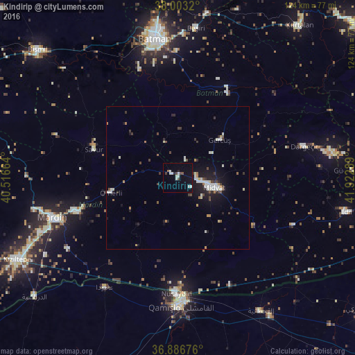
Analysis of Kindirip night lights 2016
Square area 10x10 km:
 1.3%
1.3%90-99
4.55%80-89
0%70-79
0%60-69
0.65%50-59
0.65%40-49
2.44%30-39
0.16%20-29
1.3%10-19
4.22%0-9
84.74%Square area 50x50 km:
0.5%90-99
0.96%80-89
0.25%70-79
0.27%60-69
0.39%50-59
0.37%40-49
0.65%30-39
0.5%20-29
0.77%10-19
2.97%0-9
92.36%Clear (daylight) street map image can be seen on geolist.org.
Map coordinates:
38° 0' 11.5" North, 40° 30' 59.9" East
37° 26' 49.4" North, 41° 13' 11.1" East
36° 53' 12.3" North, 41° 55' 22.4" East
Some cities around Kindirip sort by population:
• Midyat
11 km =6.8 mi,  106°
106°
• Ebish
3.3 km =2.1 mi,  303°
303°
• Gerdzhyush
18.9 km =11.7 mi,  47°
47°
• Çavuşlu
6.6 km =4.1 mi,  22°
22°
• Acırlı
6.7 km =4.2 mi,  81°
81°
• Gelinkaya
5.6 km =3.5 mi,  127°
127°
• Yolbaşı
10.9 km =6.8 mi, 127°
• Kayapınar
13.3 km =8.3 mi,  337°
337°
300438 (p: 7,798)
Sources (retrieved 2019-11-25):
» Earth at Night: Flat Maps 2012, 2016