Acırlı night lights from space
Night Light of Acırlı (Mardin) from space (Turkey) Src. Average luminocity for 10x10km area is 24.6916% and for 50x50km: 3.9308%.
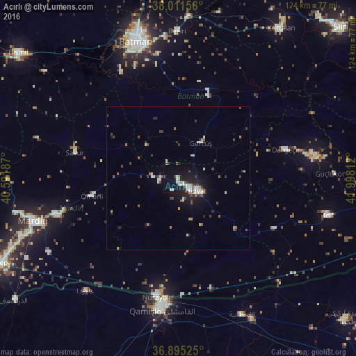
Analysis of Acırlı night lights 2016
Square area 10x10 km:
 4.55%
4.55%90-99
8.44%80-89
1.46%70-79
0.49%60-69
1.79%50-59
0.97%40-49
1.46%30-39
1.3%20-29
3.57%10-19
28.57%0-9
47.4%Square area 50x50 km:
0.46%90-99
0.86%80-89
0.25%70-79
0.26%60-69
0.39%50-59
0.41%40-49
0.69%30-39
0.61%20-29
0.73%10-19
2.86%0-9
92.47%Clear (daylight) street map image can be seen on geolist.org.
Map coordinates:
38° 0' 41.6" North, 40° 35' 30.7" East
37° 27' 19.8" North, 41° 17' 42" East
36° 53' 42.9" North, 41° 59' 53.2" East
Some cities around Acırlı sort by population:
• Midyat
5.6 km =3.5 mi,  136°
136°
• Ebish
9.4 km =5.8 mi,  275°
275°
• Gerdzhyush
13.9 km =8.6 mi,  31°
31°
• Çavuşlu
6.6 km =4.1 mi,  321°
321°
• Kindirip
6.7 km =4.2 mi,  261°
261°
• Gelinkaya
4.8 km =3 mi,  207°
207°
• Yolbaşı
7.9 km =4.9 mi,  165°
165°
• Kayapınar
16.3 km =10.1 mi,  314°
314°
325420 (p: 7,553)
Sources (retrieved 2019-11-25):
» Earth at Night: Flat Maps 2012, 2016