Slovenj Gradec night lights from space
Night Light of Slovenj Gradec from space (Slovenia) Src. Average luminocity for 10x10km area is 3.2585% and for 50x50km: 1.8277%.
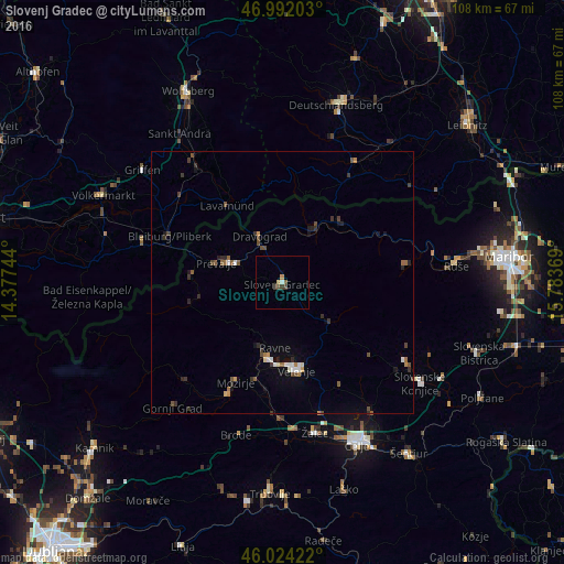
Analysis of Slovenj Gradec night lights 2016
Square area 10x10 km:
 0%
0%90-99
0.57%80-89
0.43%70-79
0.71%60-69
0%50-59
0.43%40-49
1.85%30-39
0.57%20-29
0%10-19
0%0-9
95.45%Square area 50x50 km:
0.13%90-99
0.22%80-89
0.12%70-79
0.16%60-69
0.19%50-59
0.33%40-49
0.49%30-39
0.47%20-29
0.38%10-19
0.48%0-9
97.01%Clear (daylight) street map image can be seen on geolist.org.
Map coordinates:
46° 59' 31.3" North, 14° 22' 38.8" East
46° 30' 37" North, 15° 4' 50" East
46° 1' 27.2" North, 15° 47' 1.3" East
Some cities around Slovenj Gradec sort by population:
• Ravne na Koroškem
9.3 km =5.8 mi,  293°
293°
• Prevalje
12.9 km =8 mi, 288°
• Dravograd
9.8 km =6.1 mi,  331°
331°
• Šoštanj
14.7 km =9.1 mi,  189°
189°
• Muta
13 km =8.1 mi,  30°
30°
• Mislinja
11.9 km =7.4 mi,  129°
129°
• Vuzenica
11.6 km =7.2 mi, 34°
• Ribnica na Pohorju
15 km =9.3 mi,  79°
79°
3190536 (p: 7,519)
Sources (retrieved 2019-11-25):
» Earth at Night: Flat Maps 2012, 2016