Prevalje night lights from space
Night Light of Prevalje from space (Slovenia) Src. Average luminocity for 10x10km area is 4.6349% and for 50x50km: 1.6954%.
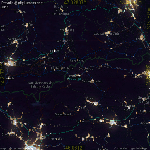
Analysis of Prevalje night lights 2016
Square area 10x10 km:
 0.28%
0.28%90-99
0.85%80-89
0%70-79
0%60-69
0.85%50-59
2.84%40-49
0.85%30-39
0%20-29
1.42%10-19
0.28%0-9
92.61%Square area 50x50 km:
0.14%90-99
0.21%80-89
0.12%70-79
0.13%60-69
0.18%50-59
0.33%40-49
0.51%30-39
0.43%20-29
0.32%10-19
0.46%0-9
97.16%Clear (daylight) street map image can be seen on geolist.org.
Map coordinates:
47° 1' 42.1" North, 14° 13' 3.8" East
46° 32' 49" North, 14° 55' 15" East
46° 3' 40.3" North, 15° 37' 26.3" East
Some cities around Prevalje sort by population:
• Slovenj Gradec
12.9 km =8 mi,  108°
108°
• Ravne na Koroškem
3.7 km =2.3 mi,  96°
96°
• Dravograd
8.8 km =5.5 mi,  58°
58°
• Mežica
5.8 km =3.6 mi,  240°
240°
• Šoštanj
21 km =13 mi,  152°
152°
• Črna na Koroškem
10.1 km =6.3 mi,  212°
212°
• Muta
20.1 km =12.5 mi,  69°
69°
• Vuzenica
19.6 km =12.2 mi, 73°
3192484 (p: 4,643)
Sources (retrieved 2019-11-25):
» Earth at Night: Flat Maps 2012, 2016