Zheleznodorozhnyy night lights from space
Night Light of Zheleznodorozhnyy (Chelyabinsk) from space (Russia) Src. Average luminocity for 10x10km area is 69.1429% and for 50x50km: 25.6526%.
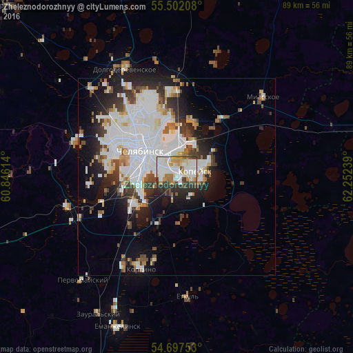
Analysis of Zheleznodorozhnyy night lights 2016
Square area 10x10 km:
 23.68%
90-99
19.55%80-89
5.01%70-79
6.89%60-69
7.89%50-59
3.51%40-49
5.26%30-39
10.65%20-29
15.41%10-19
2.13%0-9
0%Square area 50x50 km:
9.5%90-99
5.93%80-89
1.82%70-79
1.68%60-69
2.06%50-59
1.85%40-49
2.19%30-39
3.34%20-29
4.83%10-19
7.87%0-9
58.93%Clear (daylight) street map image can be seen on geolist.org.
Map coordinates:
55° 30' 7.5" North, 60° 50' 46.1" East
55° 6' 6.6" North, 61° 32' 57.3" East
54° 41' 51.1" North, 62° 15' 8.6" East
Some cities around Zheleznodorozhnyy sort by population:
• Chelyabinsk
9.6 km =6 mi,  307°
307°
• Kopeysk
5.3 km =3.3 mi,  71°
71°
• Novosineglazovskiy
13 km =8.1 mi,  237°
237°
• Roza
21.4 km =13.3 mi,  195°
195°
• Gornyak
9.2 km =5.7 mi, 66°
• Bazhovo
5.9 km =3.7 mi,  143°
143°
• Starokamyshinsk
7.4 km =4.6 mi,  160°
160°
• Potanino
9.7 km =6 mi,  28°
28°
1485193 (p: 7,337)
Sources (retrieved 2019-11-25):
» Earth at Night: Flat Maps 2012, 2016