Potanino night lights from space
Night Light of Potanino (Chelyabinsk) from space (Russia) Src. Average luminocity for 10x10km area is 46.881% and for 50x50km: 23.9959%.
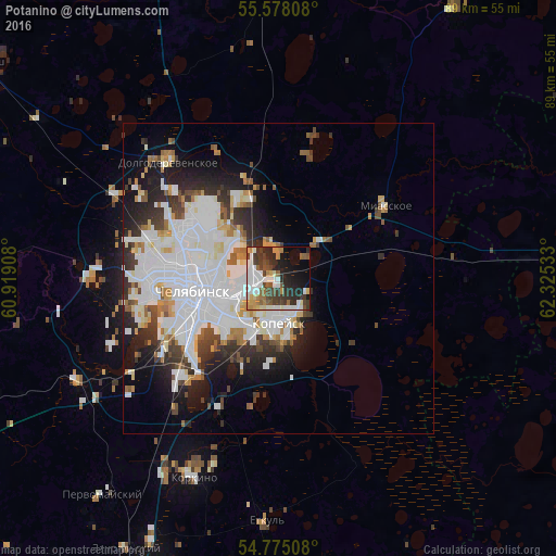
Analysis of Potanino night lights 2016
Square area 10x10 km:
 9.9%
9.9%90-99
11.28%80-89
2.88%70-79
5.14%60-69
4.64%50-59
6.14%40-49
7.02%30-39
11.9%20-29
13.91%10-19
15.41%0-9
11.78%Square area 50x50 km:
9.04%90-99
5.58%80-89
1.71%70-79
1.56%60-69
1.93%50-59
1.63%40-49
2.01%30-39
3.14%20-29
4.6%10-19
7.05%0-9
61.74%Clear (daylight) street map image can be seen on geolist.org.
Map coordinates:
55° 34' 41.1" North, 60° 55' 8.7" East
55° 10' 43" North, 61° 37' 19.9" East
54° 46' 30.3" North, 62° 19' 31.2" East
Some cities around Potanino sort by population:
• Chelyabinsk
12.6 km =7.8 mi,  257°
257°
• Kopeysk
6.8 km =4.2 mi,  176°
176°
• Novosineglazovskiy
22 km =13.7 mi,  225°
225°
• Gornyak
6.2 km =3.9 mi,  141°
141°
• Bazhovo
13.3 km =8.3 mi, 184°
• Starokamyshinsk
15.7 km =9.8 mi,  188°
188°
• Miasskoye
20.3 km =12.6 mi,  56°
56°
• Zheleznodorozhnyy
9.7 km =6 mi,  208°
208°
1494309 (p: 8,717)
Sources (retrieved 2019-11-25):
» Earth at Night: Flat Maps 2012, 2016