Sovetskaya night lights from space
Night Light of Sovetskaya (Krasnodarskiy) from space (Russia) Src. Average luminocity for 10x10km area is 2.1394% and for 50x50km: 2.7148%.
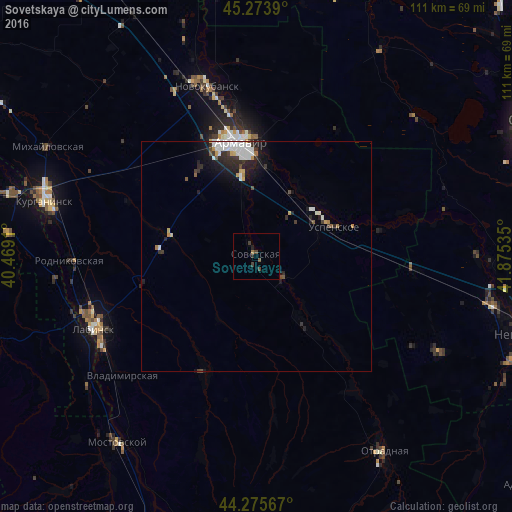
Analysis of Sovetskaya night lights 2016
Square area 10x10 km:
 0%
0%90-99
0%80-89
0%70-79
0%60-69
0.61%50-59
0.61%40-49
1.21%30-39
1.21%20-29
0.76%10-19
0.45%0-9
95.15%Square area 50x50 km:
0.6%90-99
0.65%80-89
0.13%70-79
0.22%60-69
0.18%50-59
0.19%40-49
0.25%30-39
0.44%20-29
0.99%10-19
1.63%0-9
94.71%Clear (daylight) street map image can be seen on geolist.org.
Map coordinates:
45° 16' 26" North, 40° 28' 8.8" East
44° 46' 37" North, 41° 10' 20" East
44° 16' 32.4" North, 41° 52' 31.3" East
Some cities around Sovetskaya sort by population:
• Armavir
23.9 km =14.9 mi,  350°
350°
• Labinsk
38 km =23.6 mi,  245°
245°
• Uspenskoye
18.4 km =11.4 mi,  70°
70°
• Konokovo
15.4 km =9.6 mi,  52°
52°
• Staraya Stanitsa
25.9 km =16.1 mi,  356°
356°
• Voznesenskaya
27.3 km =17 mi,  204°
204°
• Poputnaya
36.2 km =22.5 mi,  144°
144°
• Besskorbnaya
18.3 km =11.4 mi, 143°
490065 (p: 10,166)
Sources (retrieved 2019-11-25):
» Earth at Night: Flat Maps 2012, 2016