Semiluki night lights from space
Night Light of Semiluki (Voronezj) from space (Russia) Src. Average luminocity for 10x10km area is 29.091% and for 50x50km: 13.3691%.
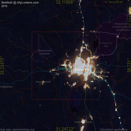
Analysis of Semiluki night lights 2016
Square area 10x10 km:
 3.64%
3.64%90-99
4.76%80-89
2.66%70-79
0.98%60-69
5.46%50-59
4.9%40-49
7%30-39
6.02%20-29
12.04%10-19
16.11%0-9
36.41%Square area 50x50 km:
4.07%90-99
2.35%80-89
0.86%70-79
0.97%60-69
1.22%50-59
1.44%40-49
1.76%30-39
2.09%20-29
4.16%10-19
6.72%0-9
74.35%Clear (daylight) street map image can be seen on geolist.org.
Map coordinates:
52° 7' 8.7" North, 38° 19' 29.1" East
51° 41' 6.9" North, 39° 1' 40.3" East
51° 14' 50" North, 39° 43' 51.6" East
Some cities around Semiluki sort by population:
• Voronezh
10.9 km =6.8 mi,  97°
97°
• Novaya Usman’
26.7 km =16.6 mi, 100°
• Pridonskoy
3.1 km =1.9 mi,  92°
92°
• Somovo
24.1 km =15 mi,  75°
75°
• Podgornoye
10 km =6.2 mi,  56°
56°
• Maslovka
20.5 km =12.7 mi,  135°
135°
• Latnaya
9.2 km =5.7 mi,  251°
251°
• Shilovo
16.1 km =10 mi,  164°
164°
497206 (p: 26,257)
Sources (retrieved 2019-11-25):
» Earth at Night: Flat Maps 2012, 2016