Opalikha night lights from space
Night Light of Opalikha (Moscow Oblast) from space (Russia) Src. Average luminocity for 10x10km area is 73.1711% and for 50x50km: 67.1434%.
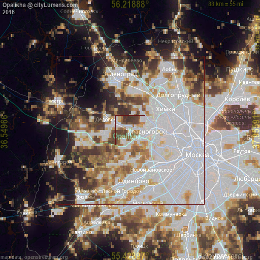
Analysis of Opalikha night lights 2016
Square area 10x10 km:
 20.57%
90-99
20.33%80-89
6.22%70-79
6.58%60-69
11%50-59
10.29%40-49
15.31%30-39
9.69%20-29
0%10-19
0%0-9
0%Square area 50x50 km:
29.75%90-99
14.66%80-89
5.23%70-79
5.5%60-69
6.35%50-59
5.56%40-49
5.64%30-39
6.3%20-29
6.34%10-19
7.61%0-9
7.07%Clear (daylight) street map image can be seen on geolist.org.
Map coordinates:
56° 13' 8" North, 36° 32' 58.8" East
55° 49' 33.3" North, 37° 15' 10" East
55° 25' 44.3" North, 37° 57' 21.3" East
Some cities around Opalikha sort by population:
• Strogino
10 km =6.2 mi,  94°
94°
• Shchukino
12.7 km =7.9 mi,  103°
103°
• Krasnogorsk
4.9 km =3 mi, 97°
• Pokrovskoye-Streshnëvo
13 km =8.1 mi, 98°
• Nakhabino
5.3 km =3.3 mi,  298°
298°
• Dedovsk
9.4 km =5.8 mi, 300°
• Rublëvo
7.8 km =4.8 mi,  125°
125°
• Pavlovskaya Sloboda
10.7 km =6.6 mi,  263°
263°
515186 (p: 5,081)
Sources (retrieved 2019-11-25):
» Earth at Night: Flat Maps 2012, 2016