Mendeleyevo night lights from space
Night Light of Mendeleyevo (Moscow Oblast) from space (Russia) Src. Average luminocity for 10x10km area is 49.0288% and for 50x50km: 38.2592%.
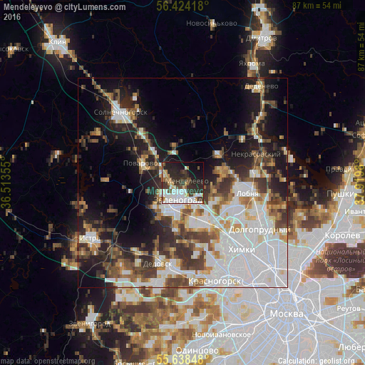
Analysis of Mendeleyevo night lights 2016
Square area 10x10 km:
 12.16%
90-99
13.41%80-89
2.76%70-79
5.51%60-69
3.01%50-59
3.01%40-49
4.76%30-39
14.04%20-29
17.67%10-19
15.79%0-9
7.89%Square area 50x50 km:
12.46%90-99
7.96%80-89
2.79%70-79
2.96%60-69
4.04%50-59
4.23%40-49
4.87%30-39
5.65%20-29
7.53%10-19
13.07%0-9
34.45%Clear (daylight) street map image can be seen on geolist.org.
Map coordinates:
56° 25' 27" North, 36° 30' 48.8" East
56° 1' 60" North, 37° 13' 0" East
55° 38' 18.5" North, 37° 55' 11.3" East
Some cities around Mendeleyevo sort by population:
• Zelenograd
6.1 km =3.8 mi,  201°
201°
• Lobnya
16.7 km =10.4 mi,  99°
99°
• Skhodnya
10.7 km =6.6 mi,  151°
151°
• Nekrasovskiy
18.8 km =11.7 mi,  69°
69°
• Novopodrezkovo
13.1 km =8.1 mi,  142°
142°
• Andreyevka
7.8 km =4.8 mi,  220°
220°
• Povarovo
11 km =6.8 mi,  289°
289°
• Sheremet’yevskiy
18.4 km =11.4 mi,  110°
110°
527581 (p: 7,964)
Sources (retrieved 2019-11-25):
» Earth at Night: Flat Maps 2012, 2016