Kolodeznyy night lights from space
Night Light of Kolodeznyy (Voronezj) from space (Russia) Src. Average luminocity for 10x10km area is 10.6541% and for 50x50km: 1.4891%.
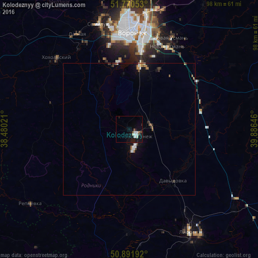
Analysis of Kolodeznyy night lights 2016
Square area 10x10 km:
 2.38%
2.38%90-99
3.22%80-89
0%70-79
0%60-69
0.7%50-59
0.7%40-49
1.68%30-39
0%20-29
1.4%10-19
11.34%0-9
78.57%Square area 50x50 km:
0.23%90-99
0.26%80-89
0.04%70-79
0.15%60-69
0.23%50-59
0.15%40-49
0.16%30-39
0.12%20-29
0.2%10-19
1.11%0-9
97.34%Clear (daylight) street map image can be seen on geolist.org.
Map coordinates:
51° 46' 13.9" North, 38° 28' 48.8" East
51° 19' 60" North, 39° 10' 60" East
50° 53' 30.9" North, 39° 53' 11.3" East
Some cities around Kolodeznyy sort by population:
• Voronezh
37.7 km =23.4 mi,  0°
0°
• Novovoronezh
3.7 km =2.3 mi,  140°
140°
• Novaya Usman’
37.7 km =23.4 mi,  24°
24°
• Pridonskoy
39.7 km =24.7 mi,  348°
348°
• Maslovka
24.7 km =15.3 mi,  8°
8°
• Shilovo
24.5 km =15.2 mi,  344°
344°
• Davydovka
26 km =16.2 mi, 138°
• Uryv-Pokrovka
24.2 km =15 mi,  183°
183°
546316 (p: 5,857)
Sources (retrieved 2019-11-25):
» Earth at Night: Flat Maps 2012, 2016