Kizlyar night lights from space
Night Light of Kizlyar (North Ossetia) from space (Russia) Src. Average luminocity for 10x10km area is 6.1727% and for 50x50km: 2.0748%.
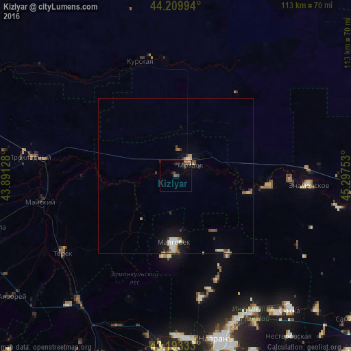
Analysis of Kizlyar night lights 2016
Square area 10x10 km:
 0.3%
0.3%90-99
0.61%80-89
0.61%70-79
0.91%60-69
0%50-59
0.76%40-49
2.73%30-39
1.97%20-29
1.06%10-19
1.67%0-9
89.39%Square area 50x50 km:
0.2%90-99
0.44%80-89
0.18%70-79
0.32%60-69
0.2%50-59
0.23%40-49
0.31%30-39
0.3%20-29
0.22%10-19
1.18%0-9
96.41%Clear (daylight) street map image can be seen on geolist.org.
Map coordinates:
44° 12' 35.8" North, 43° 53' 28.6" East
43° 42' 13.6" North, 44° 35' 39.8" East
43° 11' 36" North, 45° 17' 51.1" East
Some cities around Kizlyar sort by population:
• Staryy Malgobek
17.7 km =11 mi,  179°
179°
• Malgobek
21.4 km =13.3 mi, 181°
• Mozdok
6.4 km =4 mi,  46°
46°
• Sagopshi
24.3 km =15.1 mi, 180°
• Voznesenskaya
21.6 km =13.4 mi,  145°
145°
• Psedakh
26.4 km =16.4 mi, 184°
• Pavlodol’skaya
9.5 km =5.9 mi,  280°
280°
• Nogamerzin-Yurt
24.3 km =15.1 mi,  103°
103°
547841 (p: 8,544)
Sources (retrieved 2019-11-25):
» Earth at Night: Flat Maps 2012, 2016