Kholmskiy night lights from space
Night Light of Kholmskiy (Krasnodarskiy) from space (Russia) Src. Average luminocity for 10x10km area is 11.1683% and for 50x50km: 3.6819%.
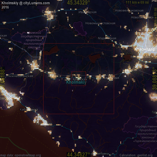
Analysis of Kholmskiy night lights 2016
Square area 10x10 km:
 0%
0%90-99
1.75%80-89
0.79%70-79
1.75%60-69
2.54%50-59
0.79%40-49
2.86%30-39
2.38%20-29
2.22%10-19
0.48%0-9
84.44%Square area 50x50 km:
0.03%90-99
0.44%80-89
0.36%70-79
0.61%60-69
0.57%50-59
0.63%40-49
0.97%30-39
0.42%20-29
0.52%10-19
2.2%0-9
93.26%Clear (daylight) street map image can be seen on geolist.org.
Map coordinates:
45° 20' 35.8" North, 37° 40' 54.8" East
44° 50' 49" North, 38° 23' 6" East
44° 20' 46.6" North, 39° 5' 17.3" East
Some cities around Kholmskiy sort by population:
• Krymsk
32.3 km =20.1 mi,  286°
286°
• Abinsk
18.1 km =11.2 mi,  277°
277°
• Il’skiy
14.3 km =8.9 mi,  92°
92°
• Severskaya
23 km =14.3 mi, 88°
• Akhtyrskiy
6.5 km =4 mi, 277°
• Afipskiy
36.5 km =22.7 mi,  80°
80°
• Chernomorskiy
8.6 km =5.3 mi, 87°
• Smolenskaya
33.7 km =20.9 mi,  101°
101°
549741 (p: 17,494)
Sources (retrieved 2019-11-25):
» Earth at Night: Flat Maps 2012, 2016