Imielin night lights from space
Night Light of Imielin (Silesia) from space (Poland) Src. Average luminocity for 10x10km area is 37.5802% and for 50x50km: 36.5808%.
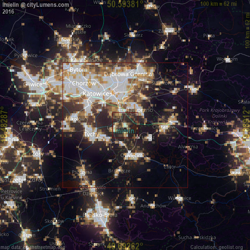
Analysis of Imielin night lights 2016
Square area 10x10 km:
 2.01%
2.01%90-99
3.74%80-89
3.61%70-79
4.81%60-69
2.81%50-59
6.02%40-49
11.36%30-39
11.76%20-29
32.62%10-19
21.26%0-9
0%Square area 50x50 km:
8.95%90-99
8.58%80-89
2.99%70-79
3.71%60-69
4.25%50-59
4.12%40-49
4.7%30-39
5.28%20-29
8.16%10-19
15.02%0-9
34.24%Clear (daylight) street map image can be seen on geolist.org.
Map coordinates:
50° 35' 37.7" North, 18° 28' 58.3" East
50° 8' 43.2" North, 19° 11' 9.6" East
49° 41' 33.4" North, 19° 53' 20.8" East
Some cities around Imielin sort by population:
• Jaworzno
9.2 km =5.7 mi,  43°
43°
• Mysłowice
7 km =4.3 mi,  348°
348°
• Bieruń
9 km =5.6 mi,  227°
227°
• Libiąż
10.3 km =6.4 mi,  116°
116°
• Lędziny
3.9 km =2.4 mi,  265°
265°
• Chełmek
6.6 km =4.1 mi,  137°
137°
• Murcki
11.8 km =7.3 mi,  301°
301°
• Chełm Śląski
4.2 km =2.6 mi,  170°
170°
3097886 (p: 8,057)
Sources (retrieved 2019-11-25):
» Earth at Night: Flat Maps 2012, 2016