Mirwah Gorchani night lights from space
Night Light of Mirwah Gorchani (Sindh) from space (Pakistan) Src. Average luminocity for 10x10km area is 2.0893% and for 50x50km: 2.3191%.
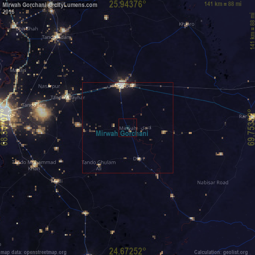
Analysis of Mirwah Gorchani night lights 2016
Square area 10x10 km:
 0%
0%90-99
0%80-89
0.79%70-79
0%60-69
0%50-59
0%40-49
0.99%30-39
1.19%20-29
0.99%10-19
0%0-9
96.03%Square area 50x50 km:
0.1%90-99
0.38%80-89
0.35%70-79
0.26%60-69
0.23%50-59
0.32%40-49
0.48%30-39
0.62%20-29
0.6%10-19
1.37%0-9
95.29%Clear (daylight) street map image can be seen on geolist.org.
Map coordinates:
25° 56' 37.5" North, 68° 20' 49.5" East
25° 18' 35.3" North, 69° 3' 0.7" East
24° 40' 21.1" North, 69° 45' 12" East
Some cities around Mirwah Gorchani sort by population:
• Mirpur Khas
24.5 km =15.2 mi,  351°
351°
• Tando Allahyar
37.4 km =23.2 mi,  296°
296°
• Matli
49.5 km =30.8 mi,  233°
233°
• Digri
18.1 km =11.2 mi,  160°
160°
• Chamber
24 km =14.9 mi,  265°
265°
• Samaro
34.9 km =21.7 mi,  95°
95°
• Rajo Khanani
41.3 km =25.7 mi,  208°
208°
• Pithoro
39.8 km =24.7 mi,  55°
55°
1170281 (p: 12,139)
Sources (retrieved 2019-11-25):
» Earth at Night: Flat Maps 2012, 2016