Berani night lights from space
Night Light of Berani (Sindh) from space (Pakistan) Src. Average luminocity for 10x10km area is 0.0758% and for 50x50km: 3.4739%.
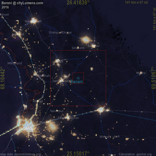
Analysis of Berani night lights 2016
Square area 10x10 km:
 0%
0%90-99
0%80-89
0%70-79
0%60-69
0%50-59
0%40-49
0%30-39
0%20-29
0%10-19
0%0-9
100%Square area 50x50 km:
0.11%90-99
0.31%80-89
0.42%70-79
0.12%60-69
0.48%50-59
0.52%40-49
1.03%30-39
0.96%20-29
0.97%10-19
2.43%0-9
92.65%Clear (daylight) street map image can be seen on geolist.org.
Map coordinates:
26° 24' 59" North, 68° 6' 15.9" East
25° 47' 5.9" North, 68° 48' 27.1" East
25° 9' 0.6" North, 69° 30' 38.4" East
Some cities around Berani sort by population:
• Mirpur Khas
35.2 km =21.9 mi,  144°
144°
• Tando Allahyar
37.2 km =23.1 mi,  194°
194°
• Tando Adam
14.7 km =9.1 mi,  262°
262°
• Shahdadpur
24.2 km =15 mi,  310°
310°
• Sanghar
32.4 km =20.1 mi,  25°
25°
• Bhit Shah
31.7 km =19.7 mi,  274°
274°
• Jhol
20.6 km =12.8 mi,  23°
23°
• Sinjhoro
27.3 km =17 mi,  0°
0°
1182953 (p: 9,975)
Sources (retrieved 2019-11-25):
» Earth at Night: Flat Maps 2012, 2016