Kiamba night lights from space
Night Light of Kiamba (Soccsksargen) from space (Philippines) Src. Average luminocity for 10x10km area is 0.0289% and for 50x50km: 0.1201%.
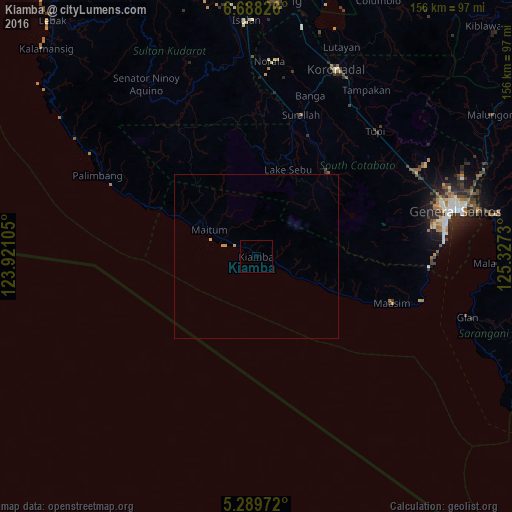
Analysis of Kiamba night lights 2016
Square area 10x10 km:
 0%
0%90-99
0%80-89
0%70-79
0%60-69
0%50-59
0%40-49
0%30-39
0%20-29
0%10-19
0%0-9
100%Square area 50x50 km:
0%90-99
0%80-89
0.03%70-79
0.1%60-69
0%50-59
0%40-49
0%30-39
0%20-29
0%10-19
0%0-9
99.86%Clear (daylight) street map image can be seen on geolist.org.
Map coordinates:
6° 41' 17.7" North, 123° 55' 15.8" East
5° 59' 22" North, 124° 37' 27" East
5° 17' 23" North, 125° 19' 38.3" East
Some cities around Kiamba sort by population:
• Surallah
44.9 km =27.9 mi,  17°
17°
• Lake Sebu
27.9 km =17.3 mi, 20°
• Santo Niño
50.2 km =31.2 mi,  9°
9°
• Maitum
14.9 km =9.3 mi,  291°
291°
• Dahay
45.7 km =28.4 mi, 12°
• Polonoling
50.3 km =31.3 mi,  49°
49°
• Lamba
45.6 km =28.3 mi,  28°
28°
• Maasim
44.7 km =27.8 mi,  109°
109°
1708903 (p: 10,979)
Sources (retrieved 2019-11-25):
» Earth at Night: Flat Maps 2012, 2016