Pacora night lights from space
Night Light of Pacora (Panamá) from space (Panama) Src. Average luminocity for 10x10km area is 34.0108% and for 50x50km: 12.0788%.
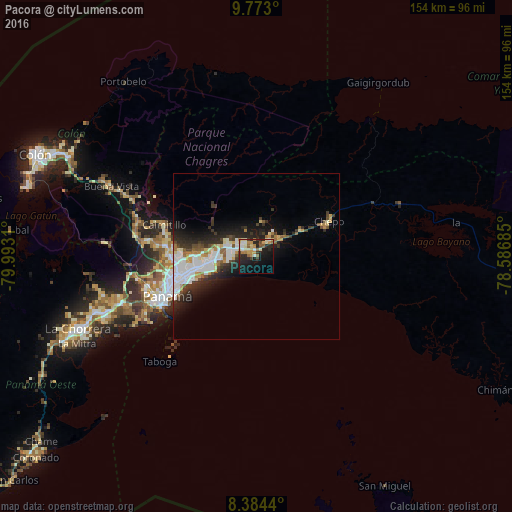
Analysis of Pacora night lights 2016
Square area 10x10 km:
 4.33%
4.33%90-99
4.98%80-89
4.55%70-79
7.58%60-69
5.41%50-59
2.81%40-49
2.38%30-39
3.68%20-29
14.07%10-19
25.32%0-9
24.89%Square area 50x50 km:
3.04%90-99
2.57%80-89
1.06%70-79
1.1%60-69
1.05%50-59
1%40-49
1.09%30-39
2.19%20-29
3.98%10-19
5.9%0-9
77.03%Clear (daylight) street map image can be seen on geolist.org.
Map coordinates:
9° 46' 22.8" North, 79° 59' 35.2" West
9° 4' 45.7" North, 79° 17' 23.9" West
8° 23' 3.8" North, 78° 35' 12.7" West
Some cities around Pacora sort by population:
• San Miguelito
20.1 km =12.5 mi,  260°
260°
• Juan Díaz
17.9 km =11.1 mi, 259°
• Pedregal
15.8 km =9.8 mi, 264°
• Tocumen
10.3 km =6.4 mi,  276°
276°
• Parque Lefevre
22.3 km =13.9 mi,  251°
251°
• Nuevo Belén
11.6 km =7.2 mi,  270°
270°
• Chepo
23.1 km =14.4 mi,  64°
64°
• Nueva Esperanza
5.5 km =3.4 mi,  297°
297°
3703647 (p: 6,856)
Sources (retrieved 2019-11-25):
» Earth at Night: Flat Maps 2012, 2016