Chepo night lights from space
Night Light of Chepo (Panamá) from space (Panama) Src. Average luminocity for 10x10km area is 11.6429% and for 50x50km: 3.1259%.
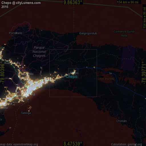
Analysis of Chepo night lights 2016
Square area 10x10 km:
 0%
0%90-99
0.65%80-89
1.95%70-79
2.6%60-69
1.73%50-59
1.95%40-49
4.11%30-39
2.6%20-29
0.87%10-19
0%0-9
83.55%Square area 50x50 km:
0.18%90-99
0.31%80-89
0.4%70-79
0.49%60-69
0.54%50-59
0.4%40-49
0.36%30-39
0.68%20-29
1.21%10-19
2.27%0-9
93.15%Clear (daylight) street map image can be seen on geolist.org.
Map coordinates:
9° 51' 49.1" North, 79° 48' 14.3" West
9° 10' 12.7" North, 79° 6' 3" West
8° 28' 31.4" North, 78° 23' 51.8" West
Some cities around Chepo sort by population:
• San Miguelito
42.7 km =26.5 mi,  251°
251°
• Juan Díaz
40.6 km =25.2 mi, 250°
• Pedregal
38.3 km =23.8 mi, 252°
• Tocumen
32.3 km =20.1 mi, 253°
• Parque Lefevre
45.3 km =28.1 mi, 247°
• Nuevo Belén
33.9 km =21.1 mi, 252°
• Nueva Esperanza
26.7 km =16.6 mi, 253°
• Pacora
23.1 km =14.4 mi,  244°
244°
3712505 (p: 12,912)
Sources (retrieved 2019-11-25):
» Earth at Night: Flat Maps 2012, 2016