Noord-Scharwoude night lights from space
Night Light of Noord-Scharwoude (North Holland) from space (Netherlands) Src. Average luminocity for 10x10km area is 48.5767% and for 50x50km: 13.0657%.
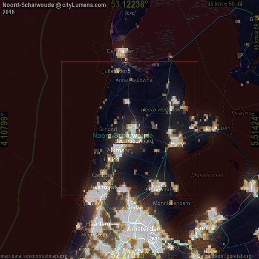
Analysis of Noord-Scharwoude night lights 2016
Square area 10x10 km:
 10.85%
90-99
11.9%80-89
4.5%70-79
3.97%60-69
5.82%50-59
6.22%40-49
5.42%30-39
6.61%20-29
15.74%10-19
23.94%0-9
5.03%Square area 50x50 km:
2.3%90-99
2.5%80-89
1.15%70-79
1.23%60-69
1.09%50-59
1.4%40-49
1.36%30-39
1.44%20-29
4.49%10-19
12.91%0-9
70.13%Clear (daylight) street map image can be seen on geolist.org.
Map coordinates:
53° 7' 20.5" North, 4° 6' 28.8" East
52° 41' 54" North, 4° 48' 40" East
52° 16' 12.5" North, 5° 30' 51.3" East
Some cities around Noord-Scharwoude sort by population:
• Alkmaar
8.5 km =5.3 mi,  209°
209°
• Heerhugowaard
3.9 km =2.4 mi,  139°
139°
• Harenkarspel
4.6 km =2.9 mi,  329°
329°
• Opmeer
9 km =5.6 mi,  84°
84°
• Zuid-Scharwoude
1.3 km =0.8 mi,  188°
188°
• Sint Pancras
4.7 km =2.9 mi,  203°
203°
• Broek op Langedijk
2.7 km =1.7 mi, 187°
• Obdam
6.9 km =4.3 mi,  111°
111°
2749835 (p: 5,665)
Sources (retrieved 2019-11-25):
» Earth at Night: Flat Maps 2012, 2016