Nieuw-Loosdrecht night lights from space
Night Light of Nieuw-Loosdrecht (North Holland) from space (Netherlands) Src. Average luminocity for 10x10km area is 26.4021% and for 50x50km: 34.3687%.
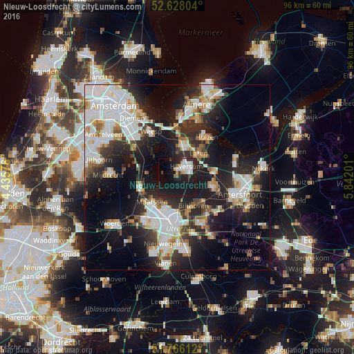
Analysis of Nieuw-Loosdrecht night lights 2016
Square area 10x10 km:
 5.82%
5.82%90-99
5.82%80-89
1.72%70-79
1.98%60-69
0.66%50-59
0.93%40-49
1.19%30-39
2.12%20-29
9.39%10-19
45.63%0-9
24.74%Square area 50x50 km:
9.46%90-99
7.66%80-89
2.91%70-79
2.99%60-69
3.18%50-59
2.63%40-49
3.09%30-39
4.24%20-29
10.45%10-19
19.28%0-9
34.12%Clear (daylight) street map image can be seen on geolist.org.
Map coordinates:
52° 37' 40.9" North, 4° 26' 8.7" East
52° 11' 57" North, 5° 8' 20" East
51° 45' 58" North, 5° 50' 31.2" East
Some cities around Nieuw-Loosdrecht sort by population:
• Hilversum
3.7 km =2.3 mi,  43°
43°
• Maarssen
9.4 km =5.8 mi,  224°
224°
• Bussum
8.4 km =5.2 mi,  10°
10°
• Baarn
10.2 km =6.3 mi,  82°
82°
• Breukelen
9.8 km =6.1 mi,  253°
253°
• Laren
8.8 km =5.5 mi, 43°
• Kortenhoef
5 km =3.1 mi,  333°
333°
• Kerkelanden
2.1 km =1.3 mi,  354°
354°
2750158 (p: 5,970)
Sources (retrieved 2019-11-25):
» Earth at Night: Flat Maps 2012, 2016