Acambay night lights from space
Night Light of Acambay (México) from space (Mexico) Src. Average luminocity for 10x10km area is 11.7684% and for 50x50km: 10.1523%.
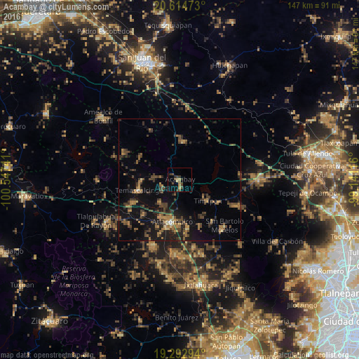
Analysis of Acambay night lights 2016
Square area 10x10 km:
 0%
0%90-99
0%80-89
1.52%70-79
1.08%60-69
3.46%50-59
0.87%40-49
4.98%30-39
4.33%20-29
1.3%10-19
1.52%0-9
80.95%Square area 50x50 km:
0.04%90-99
0.23%80-89
0.62%70-79
1.19%60-69
2.46%50-59
1.63%40-49
3.33%30-39
2.89%20-29
2.92%10-19
8.84%0-9
75.85%Clear (daylight) street map image can be seen on geolist.org.
Map coordinates:
20° 36' 53" North, 100° 32' 50.7" West
19° 57' 18.8" North, 99° 50' 39.4" West
19° 17' 34.6" North, 99° 8' 28.2" West
Some cities around Acambay sort by population:
• Atlacomulco de Fabela
17.6 km =10.9 mi,  190°
190°
• Temascalcingo
17.2 km =10.7 mi,  255°
255°
• San Lorenzo Tlacotepec
17.4 km =10.8 mi,  204°
204°
• San Francisco Tepeolulco
20.3 km =12.6 mi,  227°
227°
• Santa María Citendejé
21.2 km =13.2 mi, 204°
• Santiago Acutzilapan
20.5 km =12.7 mi,  156°
156°
• San Miguel Tenochtitlán
23.2 km =14.4 mi, 200°
• Santiago Citendejé
21.3 km =13.2 mi, 204°
3533475 (p: 5,807)
Sources (retrieved 2019-11-25):
» Earth at Night: Flat Maps 2012, 2016