Sala night lights from space
Night Light of Sala (Salas) from space (Latvia) Src. Average luminocity for 10x10km area is 2.5511% and for 50x50km: 0.6701%.
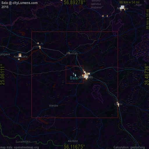
Analysis of Sala night lights 2016
Square area 10x10 km:
100  0.34%
0.34%
90-99 0.11%
80-89 0%
70-79 0.68%
60-69 0.23%
50-59 0%
40-49 0.68%
30-39 0%
20-29 0.11%
10-19 0.68%
0-9 97.16%
0.34%90-99
0.11%80-89
0%70-79
0.68%60-69
0.23%50-59
0%40-49
0.68%30-39
0%20-29
0.11%10-19
0.68%0-9
97.16%Square area 50x50 km:
100 0.09%
90-99 0.1%
80-89 0.1%
70-79 0.15%
60-69 0.06%
50-59 0.02%
40-49 0.07%
30-39 0.04%
20-29 0.07%
10-19 0.25%
0-9 99.06%
0.09%90-99
0.1%80-89
0.1%70-79
0.15%60-69
0.06%50-59
0.02%40-49
0.07%30-39
0.04%20-29
0.07%10-19
0.25%0-9
99.06%Clear (daylight) street map image can be seen on geolist.org.
Map coordinates:
56° 53' 34" North, 25° 3' 40" East
56° 30' 24.3" North, 25° 45' 51.2" East
56° 7' 0.3" North, 26° 28' 2.5" East
Some cities around Sala sort by population:
• Jēkabpils
5.8 km =3.6 mi,  98°
98°
• Līvāni
30.5 km =19 mi,  123°
123°
• Aizkraukle
33 km =20.5 mi,  289°
289°
• Krustpils
6 km =3.7 mi,  85°
85°
• Pļaviņas
12.6 km =7.8 mi,  349°
349°
• Viesīte
21.9 km =13.6 mi,  215°
215°
• Aknīste
38.4 km =23.9 mi,  181°
181°
• Koknese
25.7 km =16 mi,  308°
308°
455915 (p: 0)
Sources (retrieved 2019-11-25):
» Earth at Night: Flat Maps 2012, 2016