Batamshinskiy night lights from space
Night Light of Batamshinskiy (Aqtöbe) from space (Kazakhstan) Src. Average luminocity for 10x10km area is 1.2928% and for 50x50km: 0.1059%.
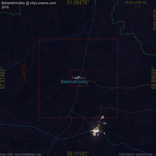
Analysis of Batamshinskiy night lights 2016
Square area 10x10 km:
 0%
0%90-99
0%80-89
0%70-79
0.53%60-69
0%50-59
0.53%40-49
0.67%30-39
0.4%20-29
0%10-19
0.13%0-9
97.73%Square area 50x50 km:
0.02%90-99
0.01%80-89
0.01%70-79
0.02%60-69
0%50-59
0.02%40-49
0.03%30-39
0.04%20-29
0.02%10-19
0.01%0-9
99.83%Clear (daylight) street map image can be seen on geolist.org.
Map coordinates:
51° 0' 17.2" North, 57° 34' 26.5" East
50° 33' 36.8" North, 58° 16' 37.7" East
50° 6' 41.1" North, 58° 58' 49" East
Some cities around Batamshinskiy sort by population:
• Aktobe
82 km =51 mi,  247°
247°
• Orsk, RU
74.5 km =46.3 mi,  15°
15°
• Novotroitsk, RU
71.6 km =44.5 mi,  2°
2°
• Gay, RU
101.5 km =63.1 mi,  7°
7°
• Mednogorsk, RU
106.1 km =65.9 mi,  333°
333°
• Khromtau
36.2 km =22.5 mi,  161°
161°
• Novoorsk, RU
103.7 km =64.4 mi,  28°
28°
• Dombarovskiy, RU
91.6 km =56.9 mi,  76°
76°
610416 (p: 5,668)
Sources (retrieved 2019-11-25):
» Earth at Night: Flat Maps 2012, 2016