Toba night lights from space
Night Light of Toba (Mie) from space (Japan) Src. Average luminocity for 10x10km area is 10.0892% and for 50x50km: 6.2791%.

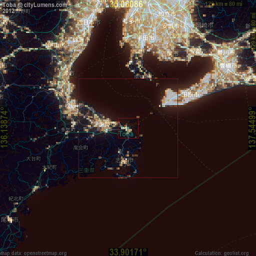
Analysis of Toba night lights 2016
Square area 10x10 km:
100  0%
0%
90-99 0.17%
80-89 3.15%
70-79 1.22%
60-69 0.7%
50-59 2.45%
40-49 2.1%
30-39 0.35%
20-29 1.75%
10-19 1.4%
0-9 86.71%
0%90-99
0.17%80-89
3.15%70-79
1.22%60-69
0.7%50-59
2.45%40-49
2.1%30-39
0.35%20-29
1.75%10-19
1.4%0-9
86.71%Square area 50x50 km:
100 0.71%
90-99 0.9%
80-89 0.83%
70-79 0.56%
60-69 0.52%
50-59 0.88%
40-49 0.71%
30-39 1.04%
20-29 2.19%
10-19 6%
0-9 85.66%
0.71%90-99
0.9%80-89
0.83%70-79
0.56%60-69
0.52%50-59
0.88%40-49
0.71%30-39
1.04%20-29
2.19%10-19
6%0-9
85.66%Clear (daylight) street map image can be seen on geolist.org.
Map coordinates:
35° 3' 39.1" North, 136° 8' 19.5" East
34° 28' 59.9" North, 136° 50' 30.7" East
33° 54' 6.2" North, 137° 32' 42" East
Some cities around Toba sort by population:
• Tsu
40.7 km =25.3 mi,  313°
313°
• Ise
13 km =8.1 mi,  270°
270°
• Tokoname
44.5 km =27.7 mi,  0°
0°
• Taketoyo
41.3 km =25.7 mi,  9°
9°
• Hisai-motomachi
39.9 km =24.8 mi,  300°
300°
• Tahara
43.9 km =27.3 mi,  62°
62°
• Ishiki
38.7 km =24 mi,  24°
24°
• Toyohama
26.5 km =16.5 mi, 18°
1850345 (p: 23,303)
Sources (retrieved 2019-11-25):
» Earth at Night: Flat Maps 2012, 2016