Valenzano night lights from space
Night Light of Valenzano (Apulia) from space (Italy) Src. Average luminocity for 10x10km area is 70.9099% and for 50x50km: 23.4777%.
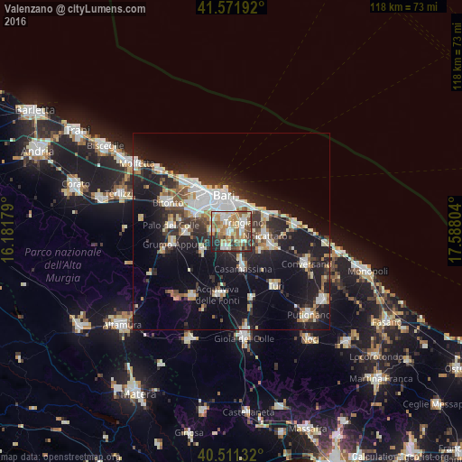
Analysis of Valenzano night lights 2016
Square area 10x10 km:
 13.95%
90-99
15.14%80-89
12.93%70-79
12.93%60-69
16.84%50-59
8.16%40-49
4.59%30-39
8.67%20-29
6.29%10-19
0.51%0-9
0%Square area 50x50 km:
4.68%90-99
4.24%80-89
2.68%70-79
2.08%60-69
2.34%50-59
2.38%40-49
2.28%30-39
3.81%20-29
7.08%10-19
18.37%0-9
50.06%Clear (daylight) street map image can be seen on geolist.org.
Map coordinates:
41° 34' 18.9" North, 16° 10' 54.4" East
41° 2' 37.5" North, 16° 53' 5.7" East
40° 30' 40.8" North, 17° 35' 16.9" East
Some cities around Valenzano sort by population:
• Bari
8.6 km =5.3 mi,  351°
351°
• Triggiano
4.1 km =2.5 mi,  54°
54°
• Noicattaro
8.8 km =5.5 mi,  96°
96°
• Adelfia
4.6 km =2.9 mi,  193°
193°
• Capurso
3.1 km =1.9 mi,  85°
85°
• Bitritto
4.9 km =3 mi,  269°
269°
• Sannicandro di Bari
8.8 km =5.5 mi,  236°
236°
• Cellamare
4.5 km =2.8 mi,  126°
126°
3164919 (p: 16,101)
Sources (retrieved 2019-11-25):
» Earth at Night: Flat Maps 2012, 2016