Noicattaro night lights from space
Night Light of Noicattaro (Apulia) from space (Italy) Src. Average luminocity for 10x10km area is 50.415% and for 50x50km: 23.1214%.
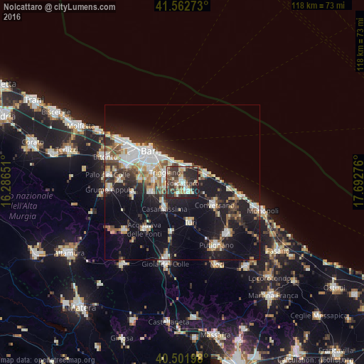

Analysis of Noicattaro night lights 2016
Square area 10x10 km:
 7.14%
7.14%90-99
8.67%80-89
6.8%70-79
4.42%60-69
5.78%50-59
8.67%40-49
9.18%30-39
19.39%20-29
23.3%10-19
6.46%0-9
0.17%Square area 50x50 km:
4.62%90-99
4.12%80-89
2.62%70-79
1.93%60-69
2.41%50-59
2.38%40-49
2.48%30-39
3.87%20-29
6.57%10-19
18.42%0-9
50.57%Clear (daylight) street map image can be seen on geolist.org.
Map coordinates:
41° 33' 45.8" North, 16° 17' 11.4" East
41° 2' 4.2" North, 16° 59' 22.7" East
40° 30' 7.1" North, 17° 41' 33.9" East
Some cities around Noicattaro sort by population:
• Triggiano
6.4 km =4 mi,  302°
302°
• Mola di Bari
8.9 km =5.5 mi,  71°
71°
• Casamassima
10.4 km =6.5 mi,  213°
213°
• Rutigliano
3 km =1.9 mi,  153°
153°
• Adelfia
10.5 km =6.5 mi,  250°
250°
• Valenzano
8.8 km =5.5 mi,  276°
276°
• Capurso
5.8 km =3.6 mi, 282°
• Cellamare
5.5 km =3.4 mi, 252°
3172228 (p: 21,988)
Sources (retrieved 2019-11-25):
» Earth at Night: Flat Maps 2012, 2016