Tencarola night lights from space
Night Light of Tencarola (Veneto) from space (Italy) Src. Average luminocity for 10x10km area is 81.446% and for 50x50km: 47.6545%.
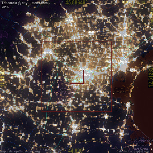
Analysis of Tencarola night lights 2016
Square area 10x10 km:
 23.65%
90-99
25.71%80-89
8.1%70-79
12.54%60-69
13.02%50-59
6.98%40-49
7.94%30-39
2.06%20-29
0%10-19
0%0-9
0%Square area 50x50 km:
6.94%90-99
8.93%80-89
4.58%70-79
5.78%60-69
7.65%50-59
10.26%40-49
10.21%30-39
8.17%20-29
13.33%10-19
17.24%0-9
6.92%Clear (daylight) street map image can be seen on geolist.org.
Map coordinates:
45° 53' 11.4" North, 11° 6' 21.9" East
45° 23' 41.6" North, 11° 48' 33.1" East
44° 53' 56.4" North, 12° 30' 44.4" East
Some cities around Tencarola sort by population:
• Padova
6.2 km =3.9 mi,  76°
76°
• Abano Terme
4.5 km =2.8 mi,  202°
202°
• Albignasego
7 km =4.3 mi,  139°
139°
• Selvazzano Dentro
1.5 km =0.9 mi,  238°
238°
• Sarmeola
3.3 km =2.1 mi,  10°
10°
• Mestrino
6.5 km =4 mi,  323°
323°
• Mandriola-Sant'Agostino
4.3 km =2.7 mi,  131°
131°
• Caselle
1.9 km =1.2 mi,  17°
17°
3165824 (p: 6,308)
Sources (retrieved 2019-11-25):
» Earth at Night: Flat Maps 2012, 2016